Ceadîr-Lunga geodata
Ceadîr-Lunga (Găgăuzia) is a populated place; located in Moldova in Europe/Chisinau (GMT+3) time zone. With population of 22,700 people, there are 12 cities with bigger population in this country. Compared to other cities in Moldova, 94.5% of cities are located further ↑North; 60.3% of cities are located further ←West and 75.3% of cities have higher elevation than Ceadîr-Lunga. Note1


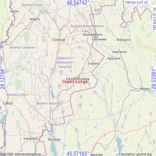
Ceadîr-Lunga GPS coordinates[2]
46° 3' 42.084" North, 28° 49' 50.808" East
| Map corner | latitude | longitude |
|---|---|---|
| Upper-left | 46.54742°, | 28.12766° |
| Center: | 46.06169°, | 28.83078° |
| Lower-right: | 45.57165°, | 29.53391° |
| Map W x H: | 108.5×108.5 km | = 67.4×67.4mi |
| max Lat: | 48.43285° ⇑94.5% North |
| Ceadîr-Lunga: | 46.06169° |
| min Lat: | ⇓5.5% South 45.48167° |
| min Long | Ceadîr-Lunga | max Long |
| 27.07787° | 28.83078° | 29.9617° |
| W 60.3%⇐ | ⇒39.7% E |
Elevation
Elevation of Ceadîr-Lunga is 45 m = 148 ft, and this is 47.8 m = 157 ft below average elevation for this country.
| Max E: |
241 m = 791 ft | 75.3% |
| Avg. | 92.8 m = 304 ft | |
| Ceadîr-Lunga | 45 m = 148 ft | |
Min E: |
11 m = 36 ft | 24.7% |
See also: Moldova elevation on elevation.city.
Geographical zone
Ceadîr-Lunga is located in North temperate zone (between Tropic of Cancer and the Arctic Circle). Distance of this North polar circle is 2279.6 km =1416.5 mi to North.| Distance of | km | miles | from Ceadîr-Lunga |
|---|---|---|---|
| North Pole | 4885.5 | 3035.7 | to North |
| Arctic Circle | 2279.6 | 1416.5 | to North |
| Tropic Cancer | 2515.7 | 1563.2 | to South |
| Equator | 5121.6 | 3182.4 | to South |


Nearby cities:
15 places around Ceadîr-Lunga: (largest is in red/bold)
• Basarabeasca
31.7 km =19.7 mi,  18°
18°
• Bugeac
36.2 km =22.5 mi,  339°
339°
• Cahul
51.8 km =32.2 mi,  250°
250°
• Cantemir
54 km =33.6 mi,  296°
296°
• Cimişlia
52 km =32.3 mi,  354°
354°
• Comrat
29.2 km =18.1 mi,  332°
332°
• Căuşeni
77.9 km =48.4 mi,  34°
34°
• Giurgiuleşti
81.1 km =50.4 mi,  217°
217°
• Iargara
51 km =31.7 mi,  322°
322°
• Leova
64.5 km =40.1 mi, 316°
• Taraclia
21.7 km =13.5 mi, 215°
• Tvardița
14.1 km =8.8 mi,  47°
47°
• Vişniovca
42.1 km =26.2 mi, 315°
• Vulcăneşti
53.3 km =33.1 mi, 218°
• Ştefan Vodă
81.2 km =50.5 mi, 51°
Sources, notices
• [Note1] Compared only with cities in Moldova existing in our database
• [Src1] Map data: © OpenStreetMap contributors (CC-BY-SA)
• [Src2] Other city data from geonames.org with taken over terms of usage.
• [Src3] Geographical zone / Annual Mean Temperature by Robert A. Rohde @ Wikipedia
