Vişniovca geodata
Vişniovca (Cantemir) is a populated place; located in Moldova in Europe/Chisinau (GMT+3) time zone. With population of 1,800 people, there are 69 cities with bigger population in this country. Compared to other cities in Moldova, 87.7% of cities are located further ↑North; 58.9% of cities are located further →East and 68.5% of cities have lower elevation than Vişniovca. Note1


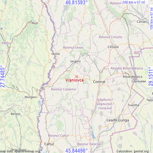
Vişniovca GPS coordinates[2]
46° 19' 57.36" North, 28° 26' 52.692" East
| Map corner | latitude | longitude |
|---|---|---|
| Upper-left | 46.81593°, | 27.74485° |
| Center: | 46.3326°, | 28.44797° |
| Lower-right: | 45.84496°, | 29.1511° |
| Map W x H: | 108×108 km | = 67.1×67.1mi |
| max Lat: | 48.43285° ⇑87.7% North |
| Vişniovca: | 46.3326° |
| min Lat: | ⇓12.3% South 45.48167° |
| min Long | Vişniovca | max Long |
| 27.07787° | 28.44797° | 29.9617° |
| W 41.1%⇐ | ⇒58.9% E |
Elevation
Elevation of Vişniovca is 116 m = 381 ft, and this is 23.2 m = 76 ft above average elevation for this country.
| Max E: |
241 m = 791 ft | 31.5% |
| Vişniovca | 116 m 381 ft | |
| Avg. | 92.8 m = 304 ft | |
Min E: |
11 m = 36 ft | 68.5% |
See also: Moldova elevation on elevation.city.
Geographical zone
Vişniovca is located in North temperate zone (between Tropic of Cancer and the Arctic Circle). Distance of this North polar circle is 2249.5 km =1397.8 mi to North.| Distance of | km | miles | from Vişniovca |
|---|---|---|---|
| North Pole | 4855.4 | 3017 | to North |
| Arctic Circle | 2249.5 | 1397.8 | to North |
| Tropic Cancer | 2545.8 | 1581.9 | to South |
| Equator | 5151.7 | 3201.1 | to South |


Nearby cities:
15 places around Vişniovca: (largest is in red/bold)
• Basarabeasca
39.6 km =24.6 mi,  90°
90°
• Bugeac
16.9 km =10.5 mi,  77°
77°
• Cahul
51.3 km =31.9 mi,  201°
201°
• Cantemir
19.8 km =12.3 mi,  251°
251°
• Ceadîr-Lunga
42.1 km =26.2 mi,  135°
135°
• Cimişlia
32.5 km =20.2 mi,  48°
48°
• Comrat
16.6 km =10.3 mi,  104°
104°
• Dancu
50.8 km =31.6 mi,  338°
338°
• Hînceşti
56.4 km =35 mi,  11°
11°
• Ialoveni
72.6 km =45.1 mi,  20°
20°
• Iargara
10.4 km =6.5 mi,  351°
351°
• Leova
22.4 km =13.9 mi,  318°
318°
• Taraclia
50.7 km =31.5 mi,  160°
160°
• Tvardița
44.7 km =27.8 mi,  117°
117°
• Vulcăneşti
72.1 km =44.8 mi,  182°
182°
Sources, notices
• [Note1] Compared only with cities in Moldova existing in our database
• [Src1] Map data: © OpenStreetMap contributors (CC-BY-SA)
• [Src2] Other city data from geonames.org with taken over terms of usage.
• [Src3] Geographical zone / Annual Mean Temperature by Robert A. Rohde @ Wikipedia
