Iargara geodata
Iargara (Cantemir) is a populated place; located in Moldova in Europe/Chisinau (GMT+3) time zone. With population of 5,600 people, there are 55 cities with bigger population in this country. Compared to other cities in Moldova, 84.9% of cities are located further ↑North; 60.3% of cities are located further →East and 76.7% of cities have lower elevation than Iargara. Note1


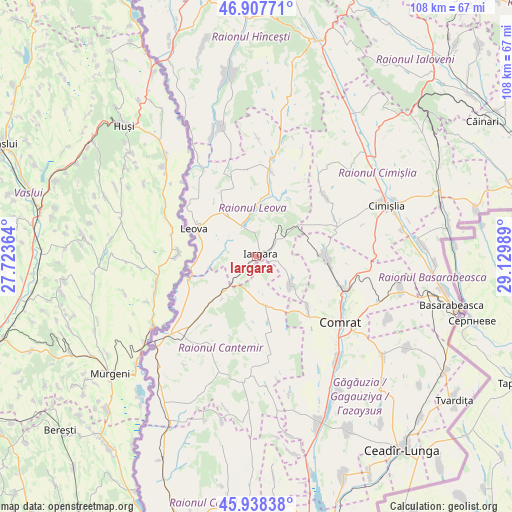
Iargara GPS coordinates[2]
46° 25' 30.72" North, 28° 25' 36.336" East
| Map corner | latitude | longitude |
|---|---|---|
| Upper-left | 46.90771°, | 27.72364° |
| Center: | 46.4252°, | 28.42676° |
| Lower-right: | 45.93838°, | 29.12989° |
| Map W x H: | 107.8×107.8 km | = 67×67mi |
| max Lat: | 48.43285° ⇑84.9% North |
| Iargara: | 46.4252° |
| min Lat: | ⇓15.1% South 45.48167° |
| min Long | Iargara | max Long |
| 27.07787° | 28.42676° | 29.9617° |
| W 39.7%⇐ | ⇒60.3% E |
Elevation
Elevation of Iargara is 125 m = 410 ft, and this is 32.2 m = 106 ft above average elevation for this country.
| Max E: |
241 m = 791 ft | 23.3% |
| Iargara | 125 m 410 ft | |
| Avg. | 92.8 m = 304 ft | |
Min E: |
11 m = 36 ft | 76.7% |
See also: Moldova elevation on elevation.city.
Geographical zone
Iargara is located in North temperate zone (between Tropic of Cancer and the Arctic Circle). Distance of this North polar circle is 2239.2 km =1391.4 mi to North.| Distance of | km | miles | from Iargara |
|---|---|---|---|
| North Pole | 4845.1 | 3010.6 | to North |
| Arctic Circle | 2239.2 | 1391.4 | to North |
| Tropic Cancer | 2556.1 | 1588.3 | to South |
| Equator | 5162 | 3207.5 | to South |


Nearby cities:
15 places around Iargara: (largest is in red/bold)
• Basarabeasca
42.5 km =26.4 mi,  104°
104°
• Bugeac
19.3 km =12 mi,  110°
110°
• Cahul
60.5 km =37.6 mi,  196°
196°
• Cantemir
23.8 km =14.8 mi,  226°
226°
• Ceadîr-Lunga
51 km =31.7 mi,  142°
142°
• Cimişlia
28.2 km =17.5 mi,  66°
66°
• Comrat
22.8 km =14.2 mi,  129°
129°
• Dancu
40.6 km =25.2 mi,  335°
335°
• Hînceşti
46.8 km =29.1 mi,  15°
15°
• Ialoveni
63.7 km =39.6 mi,  25°
25°
• Leova
14.7 km =9.1 mi,  295°
295°
• Sîngera
68.3 km =42.4 mi,  37°
37°
• Taraclia
61 km =37.9 mi,  162°
162°
• Tvardița
51.6 km =32.1 mi, 126°
• Vişniovca
10.4 km =6.5 mi,  171°
171°
Sources, notices
• [Note1] Compared only with cities in Moldova existing in our database
• [Src1] Map data: © OpenStreetMap contributors (CC-BY-SA)
• [Src2] Other city data from geonames.org with taken over terms of usage.
• [Src3] Geographical zone / Annual Mean Temperature by Robert A. Rohde @ Wikipedia
