Cimişlia geodata
Cimişlia is a seat of a first-order administrative division; located in Moldova in Europe/Chisinau (GMT+3) time zone. With population of 12,464 people, there are 29 cities with bigger population in this country. Compared to other cities in Moldova, 80.8% of cities are located further ↑North; 54.8% of cities are located further ←West and 65.8% of cities have lower elevation than Cimişlia. Note1


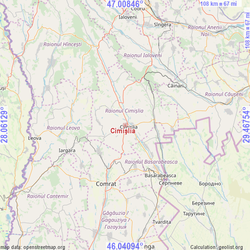
Cimişlia GPS coordinates[2]
46° 31' 36.66" North, 28° 45' 51.876" East
| Map corner | latitude | longitude |
|---|---|---|
| Upper-left | 47.00846°, | 28.06129° |
| Center: | 46.52685°, | 28.76441° |
| Lower-right: | 46.04094°, | 29.46754° |
| Map W x H: | 107.6×107.6 km | = 66.9×66.9mi |
| max Lat: | 48.43285° ⇑80.8% North |
| Cimişlia: | 46.52685° |
| min Lat: | ⇓19.2% South 45.48167° |
| min Long | Cimişlia | max Long |
| 27.07787° | 28.76441° | 29.9617° |
| W 54.8%⇐ | ⇒45.2% E |
Elevation
Elevation of Cimişlia is 115 m = 377 ft, and this is 22.2 m = 73 ft above average elevation for this country.
| Max E: |
241 m = 791 ft | 34.2% |
| Cimişlia | 115 m 377 ft | |
| Avg. | 92.8 m = 304 ft | |
Min E: |
11 m = 36 ft | 65.8% |
See also: Moldova elevation on elevation.city.
Geographical zone
Cimişlia is located in North temperate zone (between Tropic of Cancer and the Arctic Circle). Distance of this North polar circle is 2227.9 km =1384.4 mi to North.| Distance of | km | miles | from Cimişlia |
|---|---|---|---|
| North Pole | 4833.8 | 3003.6 | to North |
| Arctic Circle | 2227.9 | 1384.4 | to North |
| Tropic Cancer | 2567.4 | 1595.3 | to South |
| Equator | 5173.3 | 3214.5 | to South |


Nearby cities:
15 places around Cimişlia: (largest is in red/bold)
• Anenii Noi
53.1 km =33 mi,  42°
42°
• Basarabeasca
26.5 km =16.5 mi,  144°
144°
• Bugeac
19.6 km =12.2 mi,  203°
203°
• Cantemir
51.2 km =31.8 mi,  237°
237°
• Ceadîr-Lunga
52 km =32.3 mi,  174°
174°
• Comrat
27.1 km =16.8 mi, 197°
• Căuşeni
50.9 km =31.6 mi,  76°
76°
• Dancu
49.7 km =30.9 mi,  301°
301°
• Hînceşti
36.3 km =22.6 mi,  338°
338°
• Ialoveni
46.3 km =28.8 mi,  1°
1°
• Iargara
28.2 km =17.5 mi,  246°
246°
• Leova
39.5 km =24.5 mi,  262°
262°
• Sîngera
45.9 km =28.5 mi,  19°
19°
• Tvardița
44.8 km =27.8 mi,  159°
159°
• Vişniovca
32.5 km =20.2 mi,  228°
228°
Sources, notices
• [Note1] Compared only with cities in Moldova existing in our database
• [Src1] Map data: © OpenStreetMap contributors (CC-BY-SA)
• [Src2] Other city data from geonames.org with taken over terms of usage.
• [Src3] Geographical zone / Annual Mean Temperature by Robert A. Rohde @ Wikipedia
