Comrat geodata
Comrat (Găgăuzia) is a seat of a first-order administrative division; located in Moldova in Europe/Chisinau (GMT+3) time zone. With population of 22,911 people, there are 10 cities with bigger population in this country. Compared to other cities in Moldova, 90.4% of cities are located further ↑North; 52.1% of cities are located further →East and 63% of cities have higher elevation than Comrat. Note1


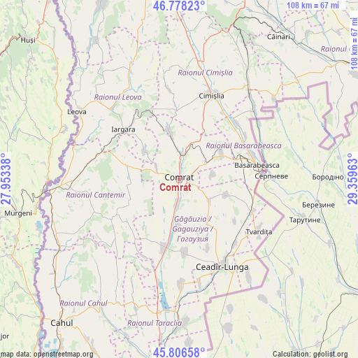
Comrat GPS coordinates[2]
46° 17' 40.416" North, 28° 39' 23.4" East
| Map corner | latitude | longitude |
|---|---|---|
| Upper-left | 46.77823°, | 27.95338° |
| Center: | 46.29456°, | 28.6565° |
| Lower-right: | 45.80658°, | 29.35963° |
| Map W x H: | 108×108 km | = 67.1×67.1mi |
| max Lat: | 48.43285° ⇑90.4% North |
| Comrat: | 46.29456° |
| min Lat: | ⇓9.6% South 45.48167° |
| min Long | Comrat | max Long |
| 27.07787° | 28.6565° | 29.9617° |
| W 47.9%⇐ | ⇒52.1% E |
Elevation
Elevation of Comrat is 62 m = 203 ft, and this is 30.8 m = 101 ft below average elevation for this country.
| Max E: |
241 m = 791 ft | 63% |
| Avg. | 92.8 m = 304 ft | |
| Comrat | 62 m = 203 ft | |
Min E: |
11 m = 36 ft | 37% |
See also: Moldova elevation on elevation.city.
Geographical zone
Comrat is located in North temperate zone (between Tropic of Cancer and the Arctic Circle). Distance of this North polar circle is 2253.7 km =1400.4 mi to North.| Distance of | km | miles | from Comrat |
|---|---|---|---|
| North Pole | 4859.6 | 3019.6 | to North |
| Arctic Circle | 2253.7 | 1400.4 | to North |
| Tropic Cancer | 2541.6 | 1579.3 | to South |
| Equator | 5147.5 | 3198.5 | to South |


Nearby cities:
15 places around Comrat: (largest is in red/bold)
• Basarabeasca
23.9 km =14.9 mi,  80°
80°
• Bugeac
7.9 km =4.9 mi,  3°
3°
• Cahul
55.9 km =34.7 mi,  219°
219°
• Cantemir
34.9 km =21.7 mi,  266°
266°
• Ceadîr-Lunga
29.2 km =18.1 mi,  152°
152°
• Cimişlia
27.1 km =16.8 mi,  17°
17°
• Căuşeni
69.2 km =43 mi,  56°
56°
• Dancu
62 km =38.5 mi,  326°
326°
• Hînceşti
59.8 km =37.2 mi,  355°
355°
• Iargara
22.8 km =14.2 mi,  309°
309°
• Leova
37.3 km =23.2 mi,  304°
304°
• Taraclia
43.6 km =27.1 mi,  178°
178°
• Tvardița
28.8 km =17.9 mi,  124°
124°
• Vişniovca
16.6 km =10.3 mi,  284°
284°
• Vulcăneşti
70.5 km =43.8 mi,  195°
195°
Sources, notices
• [Note1] Compared only with cities in Moldova existing in our database
• [Src1] Map data: © OpenStreetMap contributors (CC-BY-SA)
• [Src2] Other city data from geonames.org with taken over terms of usage.
• [Src3] Geographical zone / Annual Mean Temperature by Robert A. Rohde @ Wikipedia
