Leova geodata
Leova is a seat of a first-order administrative division; located in Moldova in Europe/Chisinau (GMT+3) time zone. With population of 14,301 people, there are 24 cities with bigger population in this country. Compared to other cities in Moldova, 83.6% of cities are located further ↑North; 71.2% of cities are located further →East and 78.1% of cities have higher elevation than Leova. Note1


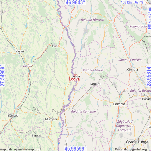
Leova GPS coordinates[2]
46° 28' 56.28" North, 28° 15' 10.836" East
| Map corner | latitude | longitude |
|---|---|---|
| Upper-left | 46.9643°, | 27.54989° |
| Center: | 46.4823°, | 28.25301° |
| Lower-right: | 45.99599°, | 28.95614° |
| Map W x H: | 107.7×107.7 km | = 66.9×66.9mi |
| max Lat: | 48.43285° ⇑83.6% North |
| Leova: | 46.4823° |
| min Lat: | ⇓16.4% South 45.48167° |
| min Long | Leova | max Long |
| 27.07787° | 28.25301° | 29.9617° |
| W 28.8%⇐ | ⇒71.2% E |
Elevation
Elevation of Leova is 37 m = 121 ft, and this is 55.8 m = 183 ft below average elevation for this country.
| Max E: |
241 m = 791 ft | 78.1% |
| Avg. | 92.8 m = 304 ft | |
| Leova | 37 m = 121 ft | |
Min E: |
11 m = 36 ft | 21.9% |
See also: Moldova elevation on elevation.city.
Geographical zone
Leova is located in North temperate zone (between Tropic of Cancer and the Arctic Circle). Distance of this North polar circle is 2232.8 km =1387.4 mi to North.| Distance of | km | miles | from Leova |
|---|---|---|---|
| North Pole | 4838.7 | 3006.6 | to North |
| Arctic Circle | 2232.8 | 1387.4 | to North |
| Tropic Cancer | 2562.4 | 1592.2 | to South |
| Equator | 5168.3 | 3211.4 | to South |


Nearby cities:
15 places around Leova: (largest is in red/bold)
• Basarabeasca
57 km =35.4 mi,  107°
107°
• Bugeac
34 km =21.1 mi, 112°
• Cahul
64.4 km =40 mi,  183°
183°
• Cantemir
23.1 km =14.4 mi,  189°
189°
• Ceadîr-Lunga
64.5 km =40.1 mi,  136°
136°
• Cimişlia
39.5 km =24.5 mi,  82°
82°
• Comrat
37.3 km =23.2 mi,  124°
124°
• Dancu
30.9 km =19.2 mi,  353°
353°
• Hînceşti
46.5 km =28.9 mi,  33°
33°
• Ialoveni
65.3 km =40.6 mi,  38°
38°
• Iargara
14.7 km =9.1 mi, 115°
• Nisporeni
66.9 km =41.6 mi, 354°
• Taraclia
71.9 km =44.7 mi,  153°
153°
• Tvardița
66.1 km =41.1 mi, 124°
• Vişniovca
22.4 km =13.9 mi, 138°
Sources, notices
• [Note1] Compared only with cities in Moldova existing in our database
• [Src1] Map data: © OpenStreetMap contributors (CC-BY-SA)
• [Src2] Other city data from geonames.org with taken over terms of usage.
• [Src3] Geographical zone / Annual Mean Temperature by Robert A. Rohde @ Wikipedia
