Marovoay geodata
Marovoay (Boeny) is a populated place; located in Madagascar in Indian/Antananarivo (GMT+3) time zone. With population of 31,253 people, there are 29 cities with bigger population in this country. Compared to other cities in Madagascar, 83.7% of cities are located further ↓South; 74.8% of cities are located further →East and 71.5% of cities have higher elevation than Marovoay. Note1
Administrative division(s):
- Level 1: Boeny
- Level 2: Marovoay District
- Level 3: Marovoay Ville
- Level 4: Itandrava


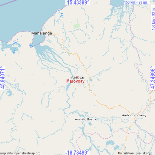
Marovoay GPS coordinates[2]
16° 6' 38.304" South, 46° 38' 37.788" East
| Map corner | latitude | longitude |
|---|---|---|
| Upper-left | -15.43399°, | 45.94071° |
| Center: | -16.11064°, | 46.64383° |
| Lower-right: | -16.78499°, | 47.34696° |
| Map W x H: | 150.2×150.2 km | = 93.3×93.3mi |
| max Lat: | -12.31732° ⇑16.3% North |
| Marovoay: | -16.11064° |
| min Lat: | ⇓83.7% South -25.3° |
| min Long | Marovoay | max Long |
| 43.65° | 46.64383° | 50.27876° |
| W 25.2%⇐ | ⇒74.8% E |
Elevation
Elevation of Marovoay is 33 m = 108 ft, and this is 524.4 m = 1720 ft below average elevation for this country.
| Max E: |
1763 m = 5784 ft | 71.5% |
| Avg. | 557.4 m = 1829 ft | |
| Marovoay | 33 m = 108 ft | |
Min E: |
1 m = 3 ft | 28.5% |
See also: Madagascar elevation on elevation.city.
Geographical zone
Marovoay is located in South Torrid zone (between Equator and Tropic of Capricorn). Distance of this Southern Tropic circle is 814.6 km =506.2 mi to South.| Distance of | km | miles | from Marovoay |
|---|---|---|---|
| Equator | 1791.3 | 1113.1 | to North |
| Tropic Capricorn | 814.6 | 506.2 | to South |
| Antarctic Circle | 5609.8 | 3485.8 | to South |
| South Pole | 8215.7 | 5105 | to South |


Nearby cities:
15 places around Marovoay: (largest is in red/bold)
• Ambato Boeny
40.3 km =25 mi,  168°
168°
• Ambatondrazaka
268.8 km =167 mi,  135°
135°
• Amparafaravola
235 km =146 mi,  134°
134°
• Andilamena
228.6 km =142 mi,  115°
115°
• Ankazobe
250.4 km =155.6 mi, 168°
• Antsirabe Afovoany
248.9 km =154.7 mi,  85°
85°
• Antsohihy
198.7 km =123.5 mi,  46°
46°
• Bemaitso
224.5 km =139.5 mi, 118°
• Fenoarivo Be
258.4 km =160.6 mi,  181°
181°
• Maevatanana
95.5 km =59.3 mi, 167°
• Mahabe
176.6 km =109.7 mi,  232°
232°
• Mahajanga
56.1 km =34.9 mi,  321°
321°
• Mandritsara
235.2 km =146.1 mi,  83°
83°
• Sitampiky
84.8 km =52.7 mi,  223°
223°
• Tsaratanana
131.8 km =81.9 mi, 125°
Sources, notices
• [Note1] Compared only with cities in Madagascar existing in our database
• [Src1] Map data: © OpenStreetMap contributors (CC-BY-SA)
• [Src2] Other city data from geonames.org with taken over terms of usage.
• [Src3] Geographical zone / Annual Mean Temperature by Robert A. Rohde @ Wikipedia
