Maevatanana geodata
Maevatanana (Betsiboka) is a seat of a first-order administrative division; located in Madagascar in Indian/Antananarivo (GMT+3) time zone. With population of 24,000 people, there are 50 cities with bigger population in this country. Compared to other cities in Madagascar, 78.9% of cities are located further ↓South; 70.7% of cities are located further →East and 65% of cities have higher elevation than Maevatanana. Note1


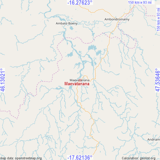
Maevatanana GPS coordinates[2]
16° 57' 0" South, 46° 49' 59.988" East
| Map corner | latitude | longitude |
|---|---|---|
| Upper-left | -16.27623°, | 46.13021° |
| Center: | -16.95°, | 46.83333° |
| Lower-right: | -17.62136°, | 47.53646° |
| Map W x H: | 149.6×149.6 km | = 93×93mi |
| max Lat: | -12.31732° ⇑21.1% North |
| Maevatanana: | -16.95° |
| min Lat: | ⇓78.9% South -25.3° |
| min Long | Maevatanana | max Long |
| 43.65° | 46.83333° | 50.27876° |
| W 29.3%⇐ | ⇒70.7% E |
Elevation
Elevation of Maevatanana is 64 m = 210 ft, and this is 493.4 m = 1619 ft below average elevation for this country.
| Max E: |
1763 m = 5784 ft | 65% |
| Avg. | 557.4 m = 1829 ft | |
| Maevatanana | 64 m = 210 ft | |
Min E: |
1 m = 3 ft | 35% |
See also: Madagascar elevation on elevation.city.
Geographical zone
Maevatanana is located in South Torrid zone (between Equator and Tropic of Capricorn). Distance of this Southern Tropic circle is 721.3 km =448.2 mi to South.| Distance of | km | miles | from Maevatanana |
|---|---|---|---|
| Equator | 1884.7 | 1171.1 | to North |
| Tropic Capricorn | 721.3 | 448.2 | to South |
| Antarctic Circle | 5516.5 | 3427.8 | to South |
| South Pole | 8122.4 | 5047 | to South |


Nearby cities:
15 places around Maevatanana: (largest is in red/bold)
• Ambato Boeny
55.2 km =34.3 mi,  346°
346°
• Ambatondrazaka
194.6 km =120.9 mi,  120°
120°
• Ambohitrolomahitsy
214.4 km =133.2 mi,  155°
155°
• Amparafaravola
163.8 km =101.8 mi, 115°
• Andilamena
185.1 km =115 mi,  92°
92°
• Anjozorobe
194.9 km =121.1 mi,  145°
145°
• Ankazobe
154.9 km =96.3 mi,  168°
168°
• Bemaitso
177.7 km =110.4 mi, 94°
• Fenoarivo Be
167.3 km =104 mi,  189°
189°
• Mahabe
160.2 km =99.5 mi,  264°
264°
• Mahajanga
147.8 km =91.8 mi,  338°
338°
• Marovoay
95.5 km =59.3 mi, 347°
• Sadabe
208.4 km =129.5 mi, 153°
• Sitampiky
84.2 km =52.3 mi,  291°
291°
• Tsaratanana
88.7 km =55.1 mi,  78°
78°
Sources, notices
• [Note1] Compared only with cities in Madagascar existing in our database
• [Src1] Map data: © OpenStreetMap contributors (CC-BY-SA)
• [Src2] Other city data from geonames.org with taken over terms of usage.
• [Src3] Geographical zone / Annual Mean Temperature by Robert A. Rohde @ Wikipedia
