Mahajanga geodata
Mahajanga (Boeny) is a seat of a first-order administrative division; located in Madagascar in Indian/Antananarivo (GMT+3) time zone. With population of 154,657 people, there are 4 cities with bigger population in this country. Compared to other cities in Madagascar, 86.2% of cities are located further ↓South; 78% of cities are located further →East and 78% of cities have higher elevation than Mahajanga. Note1


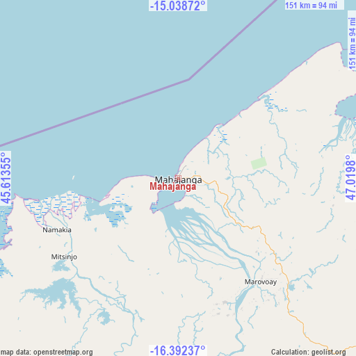
Mahajanga GPS coordinates[2]
15° 43' 0.012" South, 46° 19' 0.012" East
| Map corner | latitude | longitude |
|---|---|---|
| Upper-left | -15.03872°, | 45.61355° |
| Center: | -15.71667°, | 46.31667° |
| Lower-right: | -16.39237°, | 47.0198° |
| Map W x H: | 150.5×150.5 km | = 93.5×93.5mi |
| max Lat: | -12.31732° ⇑13.8% North |
| Mahajanga: | -15.71667° |
| min Lat: | ⇓86.2% South -25.3° |
| min Long | Mahajanga | max Long |
| 43.65° | 46.31667° | 50.27876° |
| W 22%⇐ | ⇒78% E |
Elevation
Elevation of Mahajanga is 20 m = 66 ft, and this is 537.4 m = 1763 ft below average elevation for this country.
| Max E: |
1763 m = 5784 ft | 78% |
| Avg. | 557.4 m = 1829 ft | |
| Mahajanga | 20 m = 66 ft | |
Min E: |
1 m = 3 ft | 22% |
See also: Mahajanga elevation on elevation.city.
Geographical zone
Mahajanga is located in South Torrid zone (between Equator and Tropic of Capricorn). Distance of this Southern Tropic circle is 858.4 km =533.4 mi to South.| Distance of | km | miles | from Mahajanga |
|---|---|---|---|
| Equator | 1747.5 | 1085.8 | to North |
| Tropic Capricorn | 858.4 | 533.4 | to South |
| Antarctic Circle | 5653.6 | 3513 | to South |
| South Pole | 8259.5 | 5132.2 | to South |


Nearby cities:
15 places around Mahajanga: (largest is in red/bold)
• Ambato Boeny
93.7 km =58.2 mi,  152°
152°
• Amparafaravola
290.8 km =180.7 mi,  135°
135°
• Andilamena
280.4 km =174.2 mi,  120°
120°
• Ankazobe
301.3 km =187.2 mi,  163°
163°
• Antsirabe Afovoany
284.7 km =176.9 mi,  95°
95°
• Antsohihy
201.9 km =125.5 mi,  62°
62°
• Bealanana
291.9 km =181.4 mi, 63°
• Bemaitso
277.1 km =172.2 mi, 122°
• Fenoarivo Be
303.2 km =188.4 mi,  174°
174°
• Maevatanana
147.8 km =91.8 mi, 158°
• Mahabe
184.6 km =114.7 mi,  214°
214°
• Mandritsara
269.2 km =167.3 mi,  93°
93°
• Marovoay
56.1 km =34.9 mi, 141°
• Sitampiky
108.1 km =67.2 mi,  192°
192°
• Tsaratanana
186.4 km =115.8 mi,  130°
130°
Sources, notices
• [Note1] Compared only with cities in Madagascar existing in our database
• [Src1] Map data: © OpenStreetMap contributors (CC-BY-SA)
• [Src2] Other city data from geonames.org with taken over terms of usage.
• [Src3] Geographical zone / Annual Mean Temperature by Robert A. Rohde @ Wikipedia
