Rosso geodata
Rosso (Trarza) is a seat of a first-order administrative division; located in Mauritania in Africa/Nouakchott (GMT+0) time zone. With population of 48,922 people, there are 4 cities with bigger population in this country. Compared to other cities in Mauritania, 89.5% of cities are located further ↑North; 73.7% of cities are located further →East and 84.2% of cities have higher elevation than Rosso. Note1


Rosso GPS coordinates[2]
16° 30' 49.608" North, 15° 48' 18.108" West
| Map corner | latitude | longitude |
|---|---|---|
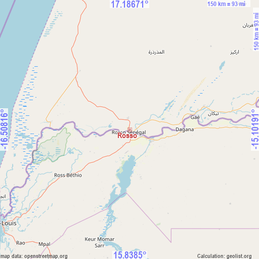
| Upper-left | 17.18671°, | -16.50816° |
| Center: | 16.51378°, | -15.80503° |
| Lower-right: | 15.8385°, | -15.10191° |
| Map W x H: | 149.9×149.9 km | = 93.1×93.1mi |
| max Lat: | 22.73542° ⇑89.5% North |
| Rosso: | 16.51378° |
| min Lat: | ⇓10.5% South 15.15846° |
| min Long | Rosso | max Long |
| -17.03842° | -15.80503° | -7.25649° |
| W 26.3%⇐ | ⇒73.7% E |
Elevation
Elevation of Rosso is 8 m = 26 ft, and this is 118.1 m = 387 ft below average elevation for this country.
| Max E: |
500 m = 1640 ft | 84.2% |
| Avg. | 126.1 m = 414 ft | |
| Rosso | 8 m = 26 ft | |
Min E: |
1 m = 3 ft | 15.8% |
See also: Rosso elevation on elevation.city.
Geographical zone
Rosso is located in North Torrid zone (between Equator and Tropic of Cancer). Distance of this Northern Tropic circle is 769.8 km =478.3 mi to North.| Distance of | km | miles | from Rosso |
|---|---|---|---|
| North Pole | 8170.9 | 5077.2 | to North |
| Arctic Circle | 5565 | 3457.9 | to North |
| Tropic Cancer | 769.8 | 478.3 | to North |
| Equator | 1836.2 | 1141 | to South |


Nearby cities:
11 places around Rosso: (largest is in red/bold)
• Akjoujt
389.5 km =242 mi,  22°
22°
• Aleg
210.1 km =130.6 mi,  73°
73°
• Arafat
171.3 km =106.4 mi,  354°
354°
• Barkéwol
352.6 km =219.1 mi,  87°
87°
• Dar Naim
177.7 km =110.4 mi,  355°
355°
• Kaédi
248.9 km =154.7 mi,  99°
99°
• Nouakchott
175.8 km =109.2 mi, 353°
• Sélibaby
415.6 km =258.2 mi,  111°
111°
• Tevragh Zeina
177.3 km =110.2 mi, 353°
• Tékane
49.6 km =30.8 mi,  78°
78°
• ’Elb el Jmel
202.9 km =126.1 mi, 74°
Sources, notices
• [Note1] Compared only with cities in Mauritania existing in our database
• [Src1] Map data: © OpenStreetMap contributors (CC-BY-SA)
• [Src2] Other city data from geonames.org with taken over terms of usage.
• [Src3] Geographical zone / Annual Mean Temperature by Robert A. Rohde @ Wikipedia
