Tékane geodata
Tékane (Trarza) is a populated place; located in Mauritania in Africa/Nouakchott (GMT+0) time zone. With population of 22,041 people, there are 8 cities with bigger population in this country. Compared to other cities in Mauritania, 84.2% of cities are located further ↑North; 68.4% of cities are located further →East and 73.7% of cities have higher elevation than Tékane. Note1


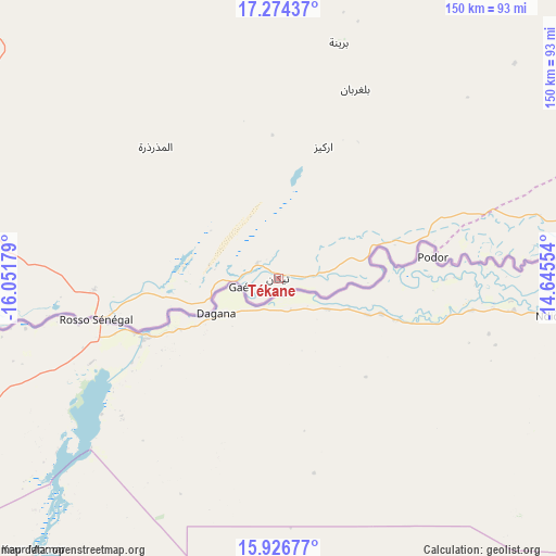
Tékane GPS coordinates[2]
16° 36' 6.3" North, 15° 20' 55.176" West
| Map corner | latitude | longitude |
|---|---|---|
| Upper-left | 17.27437°, | -16.05179° |
| Center: | 16.60175°, | -15.34866° |
| Lower-right: | 15.92677°, | -14.64554° |
| Map W x H: | 149.8×149.8 km | = 93.1×93.1mi |
| max Lat: | 22.73542° ⇑84.2% North |
| Tékane: | 16.60175° |
| min Lat: | ⇓15.8% South 15.15846° |
| min Long | Tékane | max Long |
| -17.03842° | -15.34866° | -7.25649° |
| W 31.6%⇐ | ⇒68.4% E |
Elevation
Elevation of Tékane is 11 m = 36 ft, and this is 115.1 m = 378 ft below average elevation for this country.
| Max E: |
500 m = 1640 ft | 73.7% |
| Avg. | 126.1 m = 414 ft | |
| Tékane | 11 m = 36 ft | |
Min E: |
1 m = 3 ft | 26.3% |
See also: Mauritania elevation on elevation.city.
Geographical zone
Tékane is located in North Torrid zone (between Equator and Tropic of Cancer). Distance of this Northern Tropic circle is 760 km =472.2 mi to North.| Distance of | km | miles | from Tékane |
|---|---|---|---|
| North Pole | 8161.1 | 5071.1 | to North |
| Arctic Circle | 5555.2 | 3451.8 | to North |
| Tropic Cancer | 760 | 472.2 | to North |
| Equator | 1845.9 | 1147 | to South |


Nearby cities:
12 places around Tékane: (largest is in red/bold)
• Akjoujt
364.2 km =226.3 mi,  16°
16°
• Aleg
160.8 km =99.9 mi,  71°
71°
• Arafat
173.7 km =107.9 mi,  337°
337°
• Barkéwol
303.7 km =188.7 mi,  89°
89°
• Dar Naim
178.4 km =110.9 mi, 339°
• Kaédi
203.1 km =126.2 mi,  104°
104°
• Kiffa
420.5 km =261.3 mi, 89°
• Nouakchott
178 km =110.6 mi, 337°
• Rosso
49.6 km =30.8 mi,  258°
258°
• Sélibaby
374.5 km =232.7 mi,  115°
115°
• Tevragh Zeina
179.8 km =111.7 mi, 337°
• ’Elb el Jmel
153.5 km =95.4 mi, 72°
Sources, notices
• [Note1] Compared only with cities in Mauritania existing in our database
• [Src1] Map data: © OpenStreetMap contributors (CC-BY-SA)
• [Src2] Other city data from geonames.org with taken over terms of usage.
• [Src3] Geographical zone / Annual Mean Temperature by Robert A. Rohde @ Wikipedia
