General Zaragoza geodata
General Zaragoza (Nuevo León) is a seat of a second-order administrative division; located in Mexico in America/Monterrey (GMT-6) time zone. With population of 1,941 people, there are 4483 cities with bigger population in this country. Compared to other cities in Mexico, 89.9% of cities are located further ↓South; 61.1% of cities are located further →East and 51.1% of cities have higher elevation than General Zaragoza. Note1


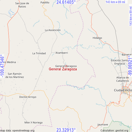
General Zaragoza GPS coordinates[2]
23° 58' 23.484" North, 99° 46' 20.388" West
| Map corner | latitude | longitude |
|---|---|---|
| Upper-left | 24.61405°, | -100.47546° |
| Center: | 23.97319°, | -99.77233° |
| Lower-right: | 23.32913°, | -99.06921° |
| Map W x H: | 142.9×142.9 km | = 88.8×88.8mi |
| max Lat: | 32.7° ⇑10.1% North |
| General Zaragoza: | 23.97319° |
| min Lat: | ⇓89.9% South 14.53588° |
| min Long | General Zaragoz | max Long |
| -117.105° | -99.77233° | -86.73105° |
| W 38.9%⇐ | ⇒61.1% E |
Elevation
Elevation of General Zaragoza is 1377 m = 4518 ft, and this is 123.3 m = 405 ft above average elevation for this country.
| Max E: |
3497 m = 11473 ft | 51.1% |
| General Zaragoza | 1377 m 4518 ft | |
| Avg. | 1253.7 m = 4113 ft | |
Min E: |
-1 m = -3 ft | 48.9% |
See also: Mexico elevation on elevation.city.
Geographical zone
General Zaragoza is located in North temperate zone (between Tropic of Cancer and the Arctic Circle). Distance of this Northern Tropic circle is 59.6 km =37 mi to South.| Distance of | km | miles | from General Zaragoza |
|---|---|---|---|
| North Pole | 7341.5 | 4561.8 | to North |
| Arctic Circle | 4735.6 | 2942.6 | to North |
| Tropic Cancer | 59.6 | 37 | to South |
| Equator | 2665.6 | 1656.3 | to South |


Nearby cities:
15 places around General Zaragoza: (largest is in red/bold)
• Aramberri
14.8 km =9.2 mi,  342°
342°
• Balconcitos (Balcones)
58.1 km =36.1 mi,  85°
85°
• Bustamante
59.8 km =37.2 mi,  178°
178°
• Doctor Arroyo
53.4 km =33.2 mi,  231°
231°
• Estación Santa Engracia
58.1 km =36.1 mi, 85°
• Guillermo Zúñiga
58.3 km =36.2 mi, 85°
• Hidalgo
45.6 km =28.3 mi,  47°
47°
• Juan Rincón
58.5 km =36.4 mi, 94°
• La Ascensión
41.6 km =25.8 mi, 339°
• La Peña
46.9 km =29.1 mi,  169°
169°
• La Trinidad
32.3 km =20.1 mi,  295°
295°
• Miquihuana
44.2 km =27.5 mi, 177°
• Oyama
54.6 km =33.9 mi,  71°
71°
• San José del Llano
51.5 km =32 mi,  198°
198°
• San Ramón de los Martínez
56.5 km =35.1 mi,  259°
259°
Sources, notices
• [Note1] Compared only with cities in Mexico existing in our database
• [Src1] Map data: © OpenStreetMap contributors (CC-BY-SA)
• [Src2] Other city data from geonames.org with taken over terms of usage.
• [Src3] Geographical zone / Annual Mean Temperature by Robert A. Rohde @ Wikipedia
