Aramberri geodata
Aramberri (Nuevo León) is a seat of a second-order administrative division; located in Mexico in America/Monterrey (GMT-6) time zone. With population of 2,538 people, there are 3493 cities with bigger population in this country. Compared to other cities in Mexico, 90.3% of cities are located further ↓South; 61.7% of cities are located further →East and 58.4% of cities have higher elevation than Aramberri. Note1


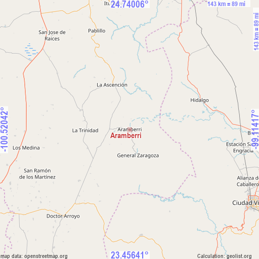
Aramberri GPS coordinates[2]
24° 5' 59.424" North, 99° 49' 2.244" West
| Map corner | latitude | longitude |
|---|---|---|
| Upper-left | 24.74006°, | -100.52042° |
| Center: | 24.09984°, | -99.81729° |
| Lower-right: | 23.45641°, | -99.11417° |
| Map W x H: | 142.7×142.7 km | = 88.7×88.7mi |
| max Lat: | 32.7° ⇑9.7% North |
| Aramberri: | 24.09984° |
| min Lat: | ⇓90.3% South 14.53588° |
| min Long | Aramberri | max Long |
| -117.105° | -99.81729° | -86.73105° |
| W 38.3%⇐ | ⇒61.7% E |
Elevation
Elevation of Aramberri is 1086 m = 3563 ft, and this is 167.7 m = 550 ft below average elevation for this country.
| Max E: |
3497 m = 11473 ft | 58.4% |
| Avg. | 1253.7 m = 4113 ft | |
| Aramberri | 1086 m = 3563 ft | |
Min E: |
-1 m = -3 ft | 41.6% |
See also: Mexico elevation on elevation.city.
Geographical zone
Aramberri is located in North temperate zone (between Tropic of Cancer and the Arctic Circle). Distance of this Northern Tropic circle is 73.7 km =45.8 mi to South.| Distance of | km | miles | from Aramberri |
|---|---|---|---|
| North Pole | 7327.4 | 4553 | to North |
| Arctic Circle | 4721.5 | 2933.8 | to North |
| Tropic Cancer | 73.7 | 45.8 | to South |
| Equator | 2679.7 | 1665.1 | to South |


Nearby cities:
15 places around Aramberri: (largest is in red/bold)
• Balconcitos (Balcones)
63.2 km =39.3 mi,  99°
99°
• Doctor Arroyo
60.3 km =37.5 mi,  217°
217°
• Estación Santa Engracia
63.2 km =39.3 mi, 98°
• General Zaragoza
14.8 km =9.2 mi,  162°
162°
• Hidalgo
41.8 km =26 mi,  66°
66°
• La Ascensión
26.8 km =16.7 mi,  338°
338°
• La Peña
61.6 km =38.3 mi,  167°
167°
• La Trinidad
24.5 km =15.2 mi,  269°
269°
• Medina
58 km =36 mi,  260°
260°
• Miquihuana
58.6 km =36.4 mi, 173°
• Oyama
56.4 km =35 mi,  86°
86°
• Pablillo
57.6 km =35.8 mi, 341°
• San Ramón de los Martínez
56.4 km =35 mi,  244°
244°
• Villa Mainero
55.1 km =34.2 mi,  21°
21°
• Villagrán
53 km =32.9 mi,  38°
38°
Sources, notices
• [Note1] Compared only with cities in Mexico existing in our database
• [Src1] Map data: © OpenStreetMap contributors (CC-BY-SA)
• [Src2] Other city data from geonames.org with taken over terms of usage.
• [Src3] Geographical zone / Annual Mean Temperature by Robert A. Rohde @ Wikipedia
