Xochinanacatlán geodata
Xochinanacatlán (Puebla) is a populated place; located in Mexico in America/Mexico_City (GMT-6) time zone. With population of 2,365 people, there are 3731 cities with bigger population in this country. Compared to other cities in Mexico, 61.2% of cities are located further ↓South; 64.9% of cities are located further ←West and 60.6% of cities have higher elevation than Xochinanacatlán. Note1


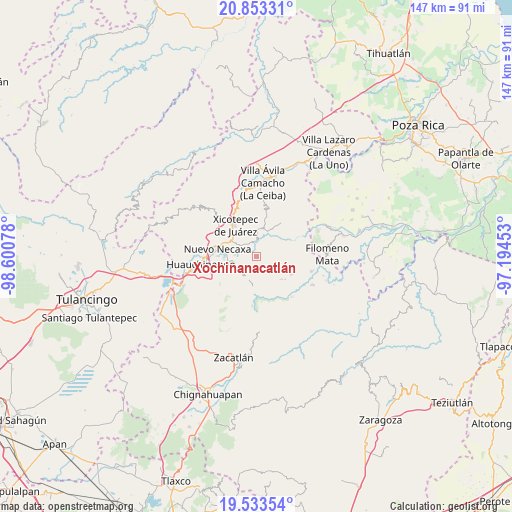
Xochinanacatlán GPS coordinates[2]
20° 11' 41.352" North, 97° 53' 51.54" West
| Map corner | latitude | longitude |
|---|---|---|
| Upper-left | 20.85331°, | -98.60078° |
| Center: | 20.19482°, | -97.89765° |
| Lower-right: | 19.53354°, | -97.19453° |
| Map W x H: | 146.7×146.7 km | = 91.2×91.2mi |
| max Lat: | 32.7° ⇑38.8% North |
| Xochinanacatlán: | 20.19482° |
| min Lat: | ⇓61.2% South 14.53588° |
| min Long | Xochinanacatlá | max Long |
| -117.105° | -97.89765° | -86.73105° |
| W 64.9%⇐ | ⇒35.1% E |
Elevation
Elevation of Xochinanacatlán is 963 m = 3159 ft, and this is 290.7 m = 954 ft below average elevation for this country.
| Max E: |
3497 m = 11473 ft | 60.6% |
| Avg. | 1253.7 m = 4113 ft | |
| Xochinanacatlán | 963 m = 3159 ft | |
Min E: |
-1 m = -3 ft | 39.4% |
See also: Mexico elevation on elevation.city.
Geographical zone
Xochinanacatlán is located in North Torrid zone (between Equator and Tropic of Cancer). Distance of this Northern Tropic circle is 360.5 km =224 mi to North.| Distance of | km | miles | from Xochinanacatlán |
|---|---|---|---|
| North Pole | 7761.6 | 4822.8 | to North |
| Arctic Circle | 5155.7 | 3203.6 | to North |
| Tropic Cancer | 360.5 | 224 | to North |
| Equator | 2245.5 | 1395.3 | to South |


Nearby cities:
15 places around Xochinanacatlán: (largest is in red/bold)
• Ahuaxintitla
6.5 km =4 mi,  1°
1°
• El Encinal
5.9 km =3.7 mi,  59°
59°
• Lagunillas
5.9 km =3.7 mi,  303°
303°
• Los Pinos
5 km =3.1 mi,  312°
312°
• Mazacoatlán
4.2 km =2.6 mi,  323°
323°
• Ocomantla
5.5 km =3.4 mi, 3°
• Patla
7.5 km =4.7 mi,  38°
38°
• Quamila
3.8 km =2.4 mi,  214°
214°
• Tecpatlán
5.9 km =3.7 mi,  32°
32°
• Telolotla
2.5 km =1.6 mi, 324°
• Tlaltepango
5.9 km =3.7 mi,  158°
158°
• Tlaola
6.8 km =4.2 mi,  202°
202°
• Tlatlapanala
4 km =2.5 mi,  233°
233°
• Tzitzicazapa
4.3 km =2.7 mi,  282°
282°
• Zihuateutla
6.3 km =3.9 mi,  9°
9°
Sources, notices
• [Note1] Compared only with cities in Mexico existing in our database
• [Src1] Map data: © OpenStreetMap contributors (CC-BY-SA)
• [Src2] Other city data from geonames.org with taken over terms of usage.
• [Src3] Geographical zone / Annual Mean Temperature by Robert A. Rohde @ Wikipedia
