El Encinal geodata
El Encinal (Puebla) is a populated place; located in Mexico in America/Mexico_City (GMT-6) time zone. With population of 554 people, there are 15392 cities with bigger population in this country. Compared to other cities in Mexico, 61.8% of cities are located further ↓South; 65.5% of cities are located further ←West and 62.7% of cities have higher elevation than El Encinal. Note1


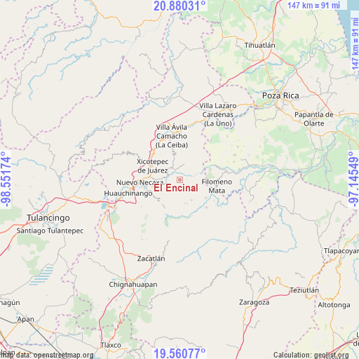
El Encinal GPS coordinates[2]
20° 13' 18.984" North, 97° 50' 54.996" West
| Map corner | latitude | longitude |
|---|---|---|
| Upper-left | 20.88031°, | -98.55174° |
| Center: | 20.22194°, | -97.84861° |
| Lower-right: | 19.56077°, | -97.14549° |
| Map W x H: | 146.7×146.7 km | = 91.2×91.2mi |
| max Lat: | 32.7° ⇑38.2% North |
| El Encinal: | 20.22194° |
| min Lat: | ⇓61.8% South 14.53588° |
| min Long | El Encinal | max Long |
| -117.105° | -97.84861° | -86.73105° |
| W 65.5%⇐ | ⇒34.5% E |
Elevation
Elevation of El Encinal is 838 m = 2749 ft, and this is 415.7 m = 1364 ft below average elevation for this country.
| Max E: |
3497 m = 11473 ft | 62.7% |
| Avg. | 1253.7 m = 4113 ft | |
| El Encinal | 838 m = 2749 ft | |
Min E: |
-1 m = -3 ft | 37.3% |
See also: Mexico elevation on elevation.city.
Geographical zone
El Encinal is located in North Torrid zone (between Equator and Tropic of Cancer). Distance of this Northern Tropic circle is 357.5 km =222.1 mi to North.| Distance of | km | miles | from El Encinal |
|---|---|---|---|
| North Pole | 7758.6 | 4821 | to North |
| Arctic Circle | 5152.7 | 3201.7 | to North |
| Tropic Cancer | 357.5 | 222.1 | to North |
| Equator | 2248.5 | 1397.2 | to South |


Nearby cities:
15 places around El Encinal: (largest is in red/bold)
• Ahuacatlaya
5.3 km =3.3 mi,  155°
155°
• Ahuaxintitla
6 km =3.7 mi,  305°
305°
• Atequexquitla
6.5 km =4 mi,  316°
316°
• Chicontla
3.1 km =1.9 mi,  37°
37°
• Cinco de Octubre
2.6 km =1.6 mi,  357°
357°
• La Unión
5 km =3.1 mi,  331°
331°
• Los Pinos
8.8 km =5.5 mi,  272°
272°
• Mazacoatlán
7.6 km =4.7 mi, 272°
• Ocomantla
5.4 km =3.4 mi,  297°
297°
• Patla
3 km =1.9 mi,  351°
351°
• San Pedro Tlaolantongo
5 km =3.1 mi,  78°
78°
• Tecpatlán
2.8 km =1.7 mi, 314°
• Telolotla
6.7 km =4.2 mi,  261°
261°
• Xochinanacatlán
5.9 km =3.7 mi,  239°
239°
• Zihuateutla
5.2 km =3.2 mi, 308°
Sources, notices
• [Note1] Compared only with cities in Mexico existing in our database
• [Src1] Map data: © OpenStreetMap contributors (CC-BY-SA)
• [Src2] Other city data from geonames.org with taken over terms of usage.
• [Src3] Geographical zone / Annual Mean Temperature by Robert A. Rohde @ Wikipedia
