Jalapilla geodata
Jalapilla (Puebla) is a populated place; located in Mexico in America/Mexico_City (GMT-6) time zone. With population of 597 people, there are 14400 cities with bigger population in this country. Compared to other cities in Mexico, 64.9% of cities are located further ↓South; 64.7% of cities are located further ←West and 68% of cities have higher elevation than Jalapilla. Note1


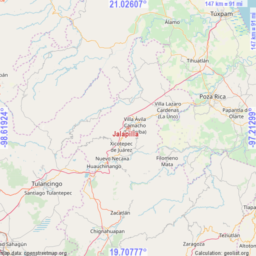
Jalapilla GPS coordinates[2]
20° 22' 5.988" North, 97° 54' 57.996" West
| Map corner | latitude | longitude |
|---|---|---|
| Upper-left | 21.02607°, | -98.61924° |
| Center: | 20.36833°, | -97.91611° |
| Lower-right: | 19.70777°, | -97.21299° |
| Map W x H: | 146.6×146.6 km | = 91.1×91.1mi |
| max Lat: | 32.7° ⇑35.1% North |
| Jalapilla: | 20.36833° |
| min Lat: | ⇓64.9% South 14.53588° |
| min Long | Jalapilla | max Long |
| -117.105° | -97.91611° | -86.73105° |
| W 64.7%⇐ | ⇒35.3% E |
Elevation
Elevation of Jalapilla is 531 m = 1742 ft, and this is 722.7 m = 2371 ft below average elevation for this country.
| Max E: |
3497 m = 11473 ft | 68% |
| Avg. | 1253.7 m = 4113 ft | |
| Jalapilla | 531 m = 1742 ft | |
Min E: |
-1 m = -3 ft | 32% |
See also: Mexico elevation on elevation.city.
Geographical zone
Jalapilla is located in North Torrid zone (between Equator and Tropic of Cancer). Distance of this Northern Tropic circle is 341.2 km =212 mi to North.| Distance of | km | miles | from Jalapilla |
|---|---|---|---|
| North Pole | 7742.3 | 4810.8 | to North |
| Arctic Circle | 5136.4 | 3191.6 | to North |
| Tropic Cancer | 341.2 | 212 | to North |
| Equator | 2264.7 | 1407.2 | to South |


Nearby cities:
15 places around Jalapilla: (largest is in red/bold)
• Agua Linda
10 km =6.2 mi,  30°
30°
• Apapantilla
8.2 km =5.1 mi,  61°
61°
• Ejido de Jalpan
10.1 km =6.3 mi,  3°
3°
• El Jericó
9.2 km =5.7 mi,  259°
259°
• Gilberto Camacho
3.2 km =2 mi,  79°
79°
• Itzatlán
8 km =5 mi,  242°
242°
• Nuevo Tenancingo
6.3 km =3.9 mi,  351°
351°
• Papaloctipan
7.4 km =4.6 mi,  326°
326°
• Plan de Ayala
7 km =4.3 mi,  357°
357°
• San Lorenzo
2.9 km =1.8 mi,  226°
226°
• San Pedro Petlacotla
4.8 km =3 mi, 2°
• Santa Rita
10.4 km =6.5 mi,  92°
92°
• Tlaxcalantongo
7.6 km =4.7 mi,  142°
142°
• Villa Avila Camacho
4.3 km =2.7 mi, 62°
• Zacatal
6.8 km =4.2 mi,  271°
271°
Sources, notices
• [Note1] Compared only with cities in Mexico existing in our database
• [Src1] Map data: © OpenStreetMap contributors (CC-BY-SA)
• [Src2] Other city data from geonames.org with taken over terms of usage.
• [Src3] Geographical zone / Annual Mean Temperature by Robert A. Rohde @ Wikipedia
