Hueyotlipan geodata
Hueyotlipan (Puebla) is a seat of a second-order administrative division; located in Mexico in America/Mexico_City (GMT-6) time zone. With population of 5,176 people, there are 1794 cities with bigger population in this country. Compared to other cities in Mexico, 67.2% of cities are located further ↑North; 65.3% of cities are located further ←West and 75.6% of cities have lower elevation than Hueyotlipan. Note1


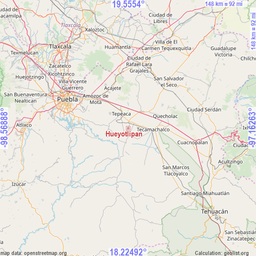
Hueyotlipan GPS coordinates[2]
18° 53' 29.328" North, 97° 51' 56.7" West
| Map corner | latitude | longitude |
|---|---|---|
| Upper-left | 19.5554°, | -98.56888° |
| Center: | 18.89148°, | -97.86575° |
| Lower-right: | 18.22492°, | -97.16263° |
| Map W x H: | 147.9×147.9 km | = 91.9×91.9mi |
| max Lat: | 32.7° ⇑67.2% North |
| Hueyotlipan: | 18.89148° |
| min Lat: | ⇓32.8% South 14.53588° |
| min Long | Hueyotlipan | max Long |
| -117.105° | -97.86575° | -86.73105° |
| W 65.3%⇐ | ⇒34.7% E |
Elevation
Elevation of Hueyotlipan is 2040 m = 6693 ft, and this is 786.3 m = 2580 ft above average elevation for this country.
| Max E: |
3497 m = 11473 ft | 24.4% |
| Hueyotlipan | 2040 m 6693 ft | |
| Avg. | 1253.7 m = 4113 ft | |
Min E: |
-1 m = -3 ft | 75.6% |
See also: Mexico elevation on elevation.city.
Geographical zone
Hueyotlipan is located in North Torrid zone (between Equator and Tropic of Cancer). Distance of this Northern Tropic circle is 505.4 km =314 mi to North.| Distance of | km | miles | from Hueyotlipan |
|---|---|---|---|
| North Pole | 7906.5 | 4912.9 | to North |
| Arctic Circle | 5300.6 | 3293.6 | to North |
| Tropic Cancer | 505.4 | 314 | to North |
| Equator | 2100.5 | 1305.2 | to South |


Nearby cities:
15 places around Hueyotlipan: (largest is in red/bold)
• Actipan
6.4 km =4 mi,  322°
322°
• Ahuatepec
6.6 km =4.1 mi,  235°
235°
• Buenavista de Juárez
7.2 km =4.5 mi,  33°
33°
• Chipiltepec
2.7 km =1.7 mi,  103°
103°
• Cuapiaxtla de Madero
5.2 km =3.2 mi,  58°
58°
• Mixtla
3.5 km =2.2 mi,  295°
295°
• Ometepec
4.3 km =2.7 mi,  162°
162°
• San Buenaventura
6.5 km =4 mi,  280°
280°
• San Hipólito
5.5 km =3.4 mi,  351°
351°
• San Martín Caltenco
5 km =3.1 mi, 98°
• San Nicolás Zoyapetlayoca
3.6 km =2.2 mi,  0°
0°
• San Simón Coatepec
3.6 km =2.2 mi, 317°
• Santa Ana Coapan
7.2 km =4.5 mi,  202°
202°
• Tlanepantla
3.9 km =2.4 mi,  215°
215°
• Zacaola
2.2 km =1.4 mi,  121°
121°
Sources, notices
• [Note1] Compared only with cities in Mexico existing in our database
• [Src1] Map data: © OpenStreetMap contributors (CC-BY-SA)
• [Src2] Other city data from geonames.org with taken over terms of usage.
• [Src3] Geographical zone / Annual Mean Temperature by Robert A. Rohde @ Wikipedia
