San Simón Coatepec geodata
San Simón Coatepec (Puebla) is a populated place; located in Mexico in America/Mexico_City (GMT-6) time zone. With population of 756 people, there are 11581 cities with bigger population in this country. Compared to other cities in Mexico, 66.7% of cities are located further ↑North; 65% of cities are located further ←West and 78.5% of cities have lower elevation than San Simón Coatepec. Note1


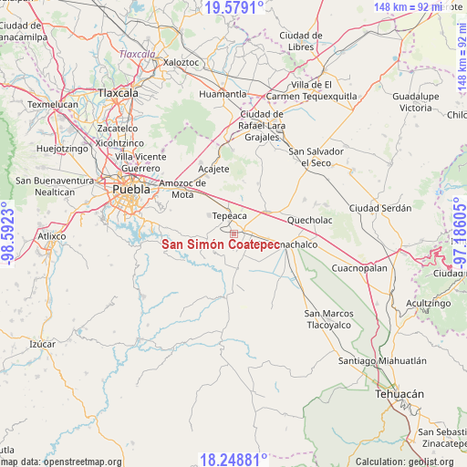
San Simón Coatepec GPS coordinates[2]
18° 54' 55.008" North, 97° 53' 21.012" West
| Map corner | latitude | longitude |
|---|---|---|
| Upper-left | 19.5791°, | -98.5923° |
| Center: | 18.91528°, | -97.88917° |
| Lower-right: | 18.24881°, | -97.18605° |
| Map W x H: | 147.9×147.9 km | = 91.9×91.9mi |
| max Lat: | 32.7° ⇑66.7% North |
| San Simón Coatepec: | 18.91528° |
| min Lat: | ⇓33.3% South 14.53588° |
| min Long | San Simón Coat | max Long |
| -117.105° | -97.88917° | -86.73105° |
| W 65%⇐ | ⇒35% E |
Elevation
Elevation of San Simón Coatepec is 2099 m = 6886 ft, and this is 845.3 m = 2773 ft above average elevation for this country.
| Max E: |
3497 m = 11473 ft | 21.5% |
| San Simón Coatepec | 2099 m 6886 ft | |
| Avg. | 1253.7 m = 4113 ft | |
Min E: |
-1 m = -3 ft | 78.5% |
See also: Mexico elevation on elevation.city.
Geographical zone
San Simón Coatepec is located in North Torrid zone (between Equator and Tropic of Cancer). Distance of this Northern Tropic circle is 502.7 km =312.4 mi to North.| Distance of | km | miles | from San Simón Coatepec |
|---|---|---|---|
| North Pole | 7903.9 | 4911.3 | to North |
| Arctic Circle | 5298 | 3292 | to North |
| Tropic Cancer | 502.7 | 312.4 | to North |
| Equator | 2103.2 | 1306.9 | to South |


Nearby cities:
15 places around San Simón Coatepec: (largest is in red/bold)
• Actipan
2.8 km =1.7 mi,  329°
329°
• Ahuatepec
7 km =4.3 mi,  205°
205°
• Buenavista de Juárez
7.3 km =4.5 mi,  62°
62°
• Chipiltepec
6 km =3.7 mi,  122°
122°
• Cuapiaxtla de Madero
6.9 km =4.3 mi,  89°
89°
• Guadalupe Calderón
6.5 km =4 mi,  29°
29°
• Hueyotlipan
3.6 km =2.2 mi,  137°
137°
• Mixtla
1.3 km =0.8 mi, 210°
• San Buenaventura
4.2 km =2.6 mi,  249°
249°
• San Hipólito
3.3 km =2.1 mi, 30°
• San Luis Ajajalpan
5.2 km =3.2 mi,  296°
296°
• San Nicolás Zoyapetlayoca
2.7 km =1.7 mi,  68°
68°
• Tepeaca
5.8 km =3.6 mi,  348°
348°
• Tlanepantla
5.8 km =3.6 mi,  177°
177°
• Zacaola
5.8 km =3.6 mi,  131°
131°
Sources, notices
• [Note1] Compared only with cities in Mexico existing in our database
• [Src1] Map data: © OpenStreetMap contributors (CC-BY-SA)
• [Src2] Other city data from geonames.org with taken over terms of usage.
• [Src3] Geographical zone / Annual Mean Temperature by Robert A. Rohde @ Wikipedia
