Tlalnepantla geodata
Tlalnepantla (Morelos) is a seat of a second-order administrative division; located in Mexico in America/Mexico_City (GMT-6) time zone. With population of 3,872 people, there are 2365 cities with bigger population in this country. Compared to other cities in Mexico, 64.6% of cities are located further ↑North; 50.3% of cities are located further ←West and 76.5% of cities have lower elevation than Tlalnepantla. Note1


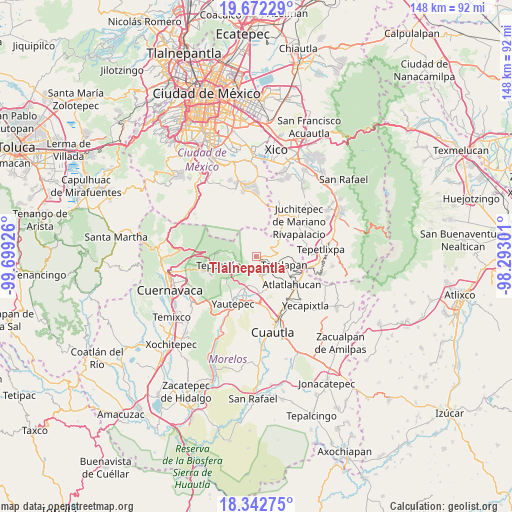
Tlalnepantla GPS coordinates[2]
19° 0' 31.86" North, 98° 59' 46.068" West
| Map corner | latitude | longitude |
|---|---|---|
| Upper-left | 19.67229°, | -99.69926° |
| Center: | 19.00885°, | -98.99613° |
| Lower-right: | 18.34275°, | -98.29301° |
| Map W x H: | 147.8×147.8 km | = 91.8×91.8mi |
| max Lat: | 32.7° ⇑64.6% North |
| Tlalnepantla: | 19.00885° |
| min Lat: | ⇓35.4% South 14.53588° |
| min Long | Tlalnepantla | max Long |
| -117.105° | -98.99613° | -86.73105° |
| W 50.3%⇐ | ⇒49.7% E |
Elevation
Elevation of Tlalnepantla is 2057 m = 6749 ft, and this is 803.3 m = 2635 ft above average elevation for this country.
| Max E: |
3497 m = 11473 ft | 23.5% |
| Tlalnepantla | 2057 m 6749 ft | |
| Avg. | 1253.7 m = 4113 ft | |
Min E: |
-1 m = -3 ft | 76.5% |
See also: Mexico elevation on elevation.city.
Geographical zone
Tlalnepantla is located in North Torrid zone (between Equator and Tropic of Cancer). Distance of this Northern Tropic circle is 492.3 km =305.9 mi to North.| Distance of | km | miles | from Tlalnepantla |
|---|---|---|---|
| North Pole | 7893.5 | 4904.8 | to North |
| Arctic Circle | 5287.6 | 3285.6 | to North |
| Tropic Cancer | 492.3 | 305.9 | to North |
| Equator | 2113.6 | 1313.3 | to South |


Nearby cities:
15 places around Tlalnepantla: (largest is in red/bold)
• Ahuatlán (Asunción Ahuatlán)
7.1 km =4.4 mi,  102°
102°
• Amatlipac (San Agustín Amatlipac)
3.9 km =2.4 mi,  134°
134°
• Amatlán de Quetzalcoatl
5.7 km =3.5 mi,  229°
229°
• Cuauhtempan (San Andrés Cuauhtempan)
6.5 km =4 mi, 125°
• El Golán
7.7 km =4.8 mi,  190°
190°
• El Pedregal
1.3 km =0.8 mi, 101°
• El Vigía
3.8 km =2.4 mi,  86°
86°
• Felipe Neri (Cuatepec)
6.5 km =4 mi,  58°
58°
• Ignacio Bastida (Santa Catarina Tlayca)
7.9 km =4.9 mi, 194°
• La Cañada (San Sebastián)
3.6 km =2.2 mi,  122°
122°
• Nacatongo
7.3 km =4.5 mi,  166°
166°
• Nepopualco
5.7 km =3.5 mi, 100°
• Santo Domingo Ocotitlán
6.8 km =4.2 mi,  275°
275°
• Tlayacapan
6.1 km =3.8 mi, 165°
• Totolapan
8.4 km =5.2 mi,  108°
108°
Sources, notices
• [Note1] Compared only with cities in Mexico existing in our database
• [Src1] Map data: © OpenStreetMap contributors (CC-BY-SA)
• [Src2] Other city data from geonames.org with taken over terms of usage.
• [Src3] Geographical zone / Annual Mean Temperature by Robert A. Rohde @ Wikipedia
