Nacuche geodata
Nacuche (Yucatán) is a populated place; located in Mexico in America/Merida (GMT-6) time zone. With population of 1,219 people, there are 7126 cities with bigger population in this country. Compared to other cities in Mexico, 75.3% of cities are located further ↓South; 99.5% of cities are located further ←West and 89.4% of cities have higher elevation than Nacuche. Note1


Nacuche GPS coordinates[2]
20° 55' 28.776" North, 88° 17' 44.952" West
| Map corner | latitude | longitude |
|---|---|---|
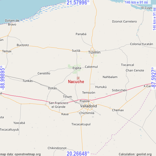
| Upper-left | 21.57996°, | -88.99895° |
| Center: | 20.92466°, | -88.29582° |
| Lower-right: | 20.26648°, | -87.5927° |
| Map W x H: | 146×146 km | = 90.7×90.7mi |
| max Lat: | 32.7° ⇑24.7% North |
| Nacuche: | 20.92466° |
| min Lat: | ⇓75.3% South 14.53588° |
| min Long | Nacuche | max Long |
| -117.105° | -88.29582° | -86.73105° |
| W 99.5%⇐ | ⇒0.5% E |
Elevation
Elevation of Nacuche is 26 m = 85 ft, and this is 1227.7 m = 4028 ft below average elevation for this country.
| Max E: |
3497 m = 11473 ft | 89.4% |
| Avg. | 1253.7 m = 4113 ft | |
| Nacuche | 26 m = 85 ft | |
Min E: |
-1 m = -3 ft | 10.6% |
See also: Mexico elevation on elevation.city.
Geographical zone
Nacuche is located in North Torrid zone (between Equator and Tropic of Cancer). Distance of this Northern Tropic circle is 279.3 km =173.5 mi to North.| Distance of | km | miles | from Nacuche |
|---|---|---|---|
| North Pole | 7680.5 | 4772.4 | to North |
| Arctic Circle | 5074.6 | 3153.2 | to North |
| Tropic Cancer | 279.3 | 173.5 | to North |
| Equator | 2326.6 | 1445.7 | to South |


Nearby cities:
15 places around Nacuche: (largest is in red/bold)
• Calotmul
16.3 km =10.1 mi,  49°
49°
• Dzitás
26 km =16.2 mi,  248°
248°
• Espita
9.7 km =6 mi,  353°
353°
• Holcá
18.8 km =11.7 mi,  8°
8°
• Hunuku
22.9 km =14.2 mi,  110°
110°
• Kunche
1.7 km =1.1 mi,  205°
205°
• Pixoy
23.4 km =14.5 mi,  171°
171°
• Pocoboch
19.6 km =12.2 mi,  73°
73°
• Popola
22.1 km =13.7 mi,  164°
164°
• Sucilá
25.8 km =16 mi,  355°
355°
• Tahmuy
24.4 km =15.2 mi,  138°
138°
• Temozon
16.6 km =10.3 mi, 143°
• Tesoco
26.8 km =16.7 mi,  146°
146°
• Tinum
20.1 km =12.5 mi, 209°
• Uayma
23.1 km =14.4 mi,  185°
185°
Sources, notices
• [Note1] Compared only with cities in Mexico existing in our database
• [Src1] Map data: © OpenStreetMap contributors (CC-BY-SA)
• [Src2] Other city data from geonames.org with taken over terms of usage.
• [Src3] Geographical zone / Annual Mean Temperature by Robert A. Rohde @ Wikipedia
