Tekoh geodata
Tekoh (Yucatán) is a populated place; located in Mexico in America/Merida (GMT-6) time zone. With population of 9,134 people, there are 1029 cities with bigger population in this country. Compared to other cities in Mexico, 72.4% of cities are located further ↓South; 98.1% of cities are located further ←West and 92.5% of cities have higher elevation than Tekoh. Note1


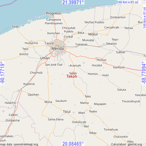
Tekoh GPS coordinates[2]
20° 44' 36.996" North, 89° 28' 26.616" West
| Map corner | latitude | longitude |
|---|---|---|
| Upper-left | 21.39971°, | -90.17719° |
| Center: | 20.74361°, | -89.47406° |
| Lower-right: | 20.08465°, | -88.77094° |
| Map W x H: | 146.2×146.2 km | = 90.8×90.8mi |
| max Lat: | 32.7° ⇑27.6% North |
| Tekoh: | 20.74361° |
| min Lat: | ⇓72.4% South 14.53588° |
| min Long | Tekoh | max Long |
| -117.105° | -89.47406° | -86.73105° |
| W 98.1%⇐ | ⇒1.9% E |
Elevation
Elevation of Tekoh is 18 m = 59 ft, and this is 1235.7 m = 4054 ft below average elevation for this country.
| Max E: |
3497 m = 11473 ft | 92.5% |
| Avg. | 1253.7 m = 4113 ft | |
| Tekoh | 18 m = 59 ft | |
Min E: |
-1 m = -3 ft | 7.5% |
See also: Mexico elevation on elevation.city.
Geographical zone
Tekoh is located in North Torrid zone (between Equator and Tropic of Cancer). Distance of this Northern Tropic circle is 299.4 km =186 mi to North.| Distance of | km | miles | from Tekoh |
|---|---|---|---|
| North Pole | 7700.6 | 4784.9 | to North |
| Arctic Circle | 5094.7 | 3165.7 | to North |
| Tropic Cancer | 299.4 | 186 | to North |
| Equator | 2306.5 | 1433.2 | to South |


Nearby cities:
15 places around Tekoh: (largest is in red/bold)
• Acanceh
8 km =5 mi,  15°
15°
• Canícab
13.7 km =8.5 mi, 18°
• Cuzama
16.3 km =10.1 mi,  90°
90°
• Eknakan
11 km =6.8 mi,  81°
81°
• Lepan
4.2 km =2.6 mi,  214°
214°
• Petectunich
10.9 km =6.8 mi,  358°
358°
• Seyé
14.8 km =9.2 mi,  46°
46°
• Subinkancab
15 km =9.3 mi,  336°
336°
• Tekik de Regil
12.2 km =7.6 mi,  311°
311°
• Telchaquillo
10.8 km =6.7 mi,  174°
174°
• Tepich Carrillo
15 km =9.3 mi,  350°
350°
• Ticopó
16.5 km =10.3 mi,  11°
11°
• Timucuy
8.5 km =5.3 mi,  330°
330°
• Uayalceh de Peón
13.7 km =8.5 mi,  246°
246°
• Yaxníc
16 km =9.9 mi,  288°
288°
Sources, notices
• [Note1] Compared only with cities in Mexico existing in our database
• [Src1] Map data: © OpenStreetMap contributors (CC-BY-SA)
• [Src2] Other city data from geonames.org with taken over terms of usage.
• [Src3] Geographical zone / Annual Mean Temperature by Robert A. Rohde @ Wikipedia
