24 de Febrero geodata
24 de Febrero (Morelos) is a populated place; located in Mexico in America/Mexico_City (GMT-6) time zone. With population of 541 people, there are 15692 cities with bigger population in this country. Compared to other cities in Mexico, 70.9% of cities are located further ↑North; 54.5% of cities are located further →East and 61% of cities have higher elevation than 24 de Febrero. Note1


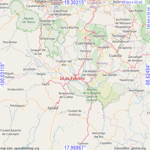
24 de Febrero GPS coordinates[2]
18° 38' 13.992" North, 99° 19' 41.016" West
| Map corner | latitude | longitude |
|---|---|---|
| Upper-left | 19.30215°, | -100.03119° |
| Center: | 18.63722°, | -99.32806° |
| Lower-right: | 17.96967°, | -98.62494° |
| Map W x H: | 148.2×148.2 km | = 92.1×92.1mi |
| max Lat: | 32.7° ⇑70.9% North |
| 24 de Febrero: | 18.63722° |
| min Lat: | ⇓29.1% South 14.53588° |
| min Long | 24 de Febrero | max Long |
| -117.105° | -99.32806° | -86.73105° |
| W 45.5%⇐ | ⇒54.5% E |
Elevation
Elevation of 24 de Febrero is 937 m = 3074 ft, and this is 316.7 m = 1039 ft below average elevation for this country.
| Max E: |
3497 m = 11473 ft | 61% |
| Avg. | 1253.7 m = 4113 ft | |
| 24 de Febrero | 937 m = 3074 ft | |
Min E: |
-1 m = -3 ft | 39% |
See also: Mexico elevation on elevation.city.
Geographical zone
24 de Febrero is located in North Torrid zone (between Equator and Tropic of Cancer). Distance of this Northern Tropic circle is 533.7 km =331.6 mi to North.| Distance of | km | miles | from 24 de Febrero |
|---|---|---|---|
| North Pole | 7934.8 | 4930.5 | to North |
| Arctic Circle | 5328.9 | 3311.2 | to North |
| Tropic Cancer | 533.7 | 331.6 | to North |
| Equator | 2072.3 | 1287.7 | to South |


Nearby cities:
15 places around 24 de Febrero: (largest is in red/bold)
• Ahuehuetzingo
5.2 km =3.2 mi,  23°
23°
• Amacuzac
6.1 km =3.8 mi,  225°
225°
• Cajones
7.2 km =4.5 mi,  195°
195°
• Casahuatlán
9.7 km =6 mi,  222°
222°
• Coahuixtla
8.3 km =5.2 mi,  212°
212°
• Coatetelco
10.3 km =6.4 mi,  1°
1°
• Cuauchichinola
5.8 km =3.6 mi,  300°
300°
• El Coco
5.4 km =3.4 mi,  163°
163°
• El Estudiante
7.4 km =4.6 mi,  153°
153°
• Miahuatlán (El Cuiji)
5.9 km =3.7 mi, 206°
• Puente de Ixtla
2.7 km =1.7 mi, 157°
• San Gabriel las Palmas
3.2 km =2 mi, 217°
• San José Vista Hermosa
6.8 km =4.2 mi,  73°
73°
• Tequesquitengo
7.7 km =4.8 mi,  112°
112°
• Xoxocotla
10.1 km =6.3 mi,  58°
58°
Sources, notices
• [Note1] Compared only with cities in Mexico existing in our database
• [Src1] Map data: © OpenStreetMap contributors (CC-BY-SA)
• [Src2] Other city data from geonames.org with taken over terms of usage.
• [Src3] Geographical zone / Annual Mean Temperature by Robert A. Rohde @ Wikipedia
