Tepetlán geodata
Tepetlán (Veracruz) is a seat of a second-order administrative division; located in Mexico in America/Mexico_City (GMT-6) time zone. With population of 2,086 people, there are 4185 cities with bigger population in this country. Compared to other cities in Mexico, 50.3% of cities are located further ↑North; 77.3% of cities are located further ←West and 55% of cities have higher elevation than Tepetlán. Note1


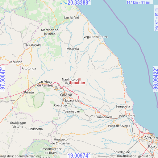
Tepetlán GPS coordinates[2]
19° 40' 23.448" North, 96° 47' 50.424" West
| Map corner | latitude | longitude |
|---|---|---|
| Upper-left | 20.33388°, | -97.50047° |
| Center: | 19.67318°, | -96.79734° |
| Lower-right: | 19.00974°, | -96.09422° |
| Map W x H: | 147.2×147.2 km | = 91.5×91.5mi |
| max Lat: | 32.7° ⇑50.3% North |
| Tepetlán: | 19.67318° |
| min Lat: | ⇓49.7% South 14.53588° |
| min Long | Tepetlán | max Long |
| -117.105° | -96.79734° | -86.73105° |
| W 77.3%⇐ | ⇒22.7% E |
Elevation
Elevation of Tepetlán is 1197 m = 3927 ft, and this is 56.7 m = 186 ft below average elevation for this country.
| Max E: |
3497 m = 11473 ft | 55% |
| Avg. | 1253.7 m = 4113 ft | |
| Tepetlán | 1197 m = 3927 ft | |
Min E: |
-1 m = -3 ft | 45% |
See also: Mexico elevation on elevation.city.
Geographical zone
Tepetlán is located in North Torrid zone (between Equator and Tropic of Cancer). Distance of this Northern Tropic circle is 418.5 km =260 mi to North.| Distance of | km | miles | from Tepetlán |
|---|---|---|---|
| North Pole | 7819.6 | 4858.9 | to North |
| Arctic Circle | 5213.7 | 3239.6 | to North |
| Tropic Cancer | 418.5 | 260 | to North |
| Equator | 2187.5 | 1359.2 | to South |


Nearby cities:
15 places around Tepetlán: (largest is in red/bold)
• Acatlán
5.4 km =3.4 mi,  299°
299°
• Almolonga
9.3 km =5.8 mi,  171°
171°
• Alto Lucero
8.6 km =5.3 mi,  129°
129°
• Cerrillos de Diaz
9 km =5.6 mi,  123°
123°
• Chiconquiaco
8 km =5 mi,  343°
343°
• El Huérfano
9.3 km =5.8 mi,  35°
35°
• Enríquez
5.7 km =3.5 mi,  83°
83°
• Landero y Coss
9 km =5.6 mi,  320°
320°
• Las Haldas
5.7 km =3.5 mi,  210°
210°
• Mafafas
4.6 km =2.9 mi,  110°
110°
• Miahuatlán
8.6 km =5.3 mi, 296°
• Naolinco de Victoria
8.2 km =5.1 mi,  255°
255°
• San Marcos Atesquilapan
9.4 km =5.8 mi,  281°
281°
• Vicente Guerrero (Tepetates)
7 km =4.3 mi,  188°
188°
• Xomotla
7.7 km =4.8 mi,  86°
86°
Sources, notices
• [Note1] Compared only with cities in Mexico existing in our database
• [Src1] Map data: © OpenStreetMap contributors (CC-BY-SA)
• [Src2] Other city data from geonames.org with taken over terms of usage.
• [Src3] Geographical zone / Annual Mean Temperature by Robert A. Rohde @ Wikipedia
