El Mirador geodata
El Mirador (Veracruz) is a populated place; located in Mexico in America/Mexico_City (GMT-6) time zone. With population of 517 people, there are 16282 cities with bigger population in this country. Compared to other cities in Mexico, 79.4% of cities are located further ↓South; 61.1% of cities are located further ←West and 76.6% of cities have higher elevation than El Mirador. Note1


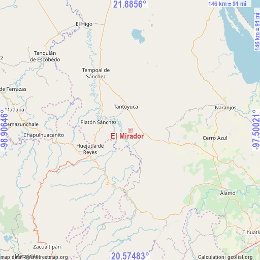
El Mirador GPS coordinates[2]
21° 13' 54.012" North, 98° 12' 11.988" West
| Map corner | latitude | longitude |
|---|---|---|
| Upper-left | 21.8856°, | -98.90646° |
| Center: | 21.23167°, | -98.20333° |
| Lower-right: | 20.57483°, | -97.50021° |
| Map W x H: | 145.7×145.7 km | = 90.5×90.5mi |
| max Lat: | 32.7° ⇑20.6% North |
| El Mirador: | 21.23167° |
| min Lat: | ⇓79.4% South 14.53588° |
| min Long | El Mirador | max Long |
| -117.105° | -98.20333° | -86.73105° |
| W 61.1%⇐ | ⇒38.9% E |
Elevation
Elevation of El Mirador is 167 m = 548 ft, and this is 1086.7 m = 3565 ft below average elevation for this country.
| Max E: |
3497 m = 11473 ft | 76.6% |
| Avg. | 1253.7 m = 4113 ft | |
| El Mirador | 167 m = 548 ft | |
Min E: |
-1 m = -3 ft | 23.4% |
See also: Mexico elevation on elevation.city.
Geographical zone
El Mirador is located in North Torrid zone (between Equator and Tropic of Cancer). Distance of this Northern Tropic circle is 245.2 km =152.4 mi to North.| Distance of | km | miles | from El Mirador |
|---|---|---|---|
| North Pole | 7646.3 | 4751.2 | to North |
| Arctic Circle | 5040.4 | 3132 | to North |
| Tropic Cancer | 245.2 | 152.4 | to North |
| Equator | 2360.7 | 1466.9 | to South |


Nearby cities:
15 places around El Mirador: (largest is in red/bold)
• Callejón Santa Clara
9.1 km =5.7 mi,  56°
56°
• Chapopote Chico
11.5 km =7.1 mi,  203°
203°
• Congreso Permanente Agrario
14.6 km =9.1 mi,  222°
222°
• Corralillo
2.8 km =1.7 mi,  331°
331°
• El Lindero
9.2 km =5.7 mi,  349°
349°
• Ixcanelco
10.3 km =6.4 mi,  174°
174°
• Los Ajos
7.4 km =4.6 mi,  125°
125°
• Moralillo
6.6 km =4.1 mi, 352°
• Rancho Viejo
14.1 km =8.8 mi,  237°
237°
• San Diego
9.5 km =5.9 mi, 172°
• San Sebastián
7.5 km =4.7 mi,  102°
102°
• Tametate
10.1 km =6.3 mi,  342°
342°
• Tantoyuca
13.4 km =8.3 mi, 350°
• Tepatlán
10.9 km =6.8 mi,  318°
318°
• Tzacuala
14 km =8.7 mi,  190°
190°
Sources, notices
• [Note1] Compared only with cities in Mexico existing in our database
• [Src1] Map data: © OpenStreetMap contributors (CC-BY-SA)
• [Src2] Other city data from geonames.org with taken over terms of usage.
• [Src3] Geographical zone / Annual Mean Temperature by Robert A. Rohde @ Wikipedia
