La Planada geodata
La Planada (State of Mexico) is a populated place; located in Mexico in America/Mexico_City (GMT-6) time zone. With population of 2,554 people, there are 3467 cities with bigger population in this country. Compared to other cities in Mexico, 52.3% of cities are located further ↓South; 52.4% of cities are located further →East and 84.5% of cities have lower elevation than La Planada. Note1


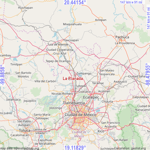
La Planada GPS coordinates[2]
19° 46' 52.644" North, 99° 10' 57.612" West
| Map corner | latitude | longitude |
|---|---|---|
| Upper-left | 20.44154°, | -99.8858° |
| Center: | 19.78129°, | -99.18267° |
| Lower-right: | 19.11829°, | -98.47955° |
| Map W x H: | 147.1×147.1 km | = 91.4×91.4mi |
| max Lat: | 32.7° ⇑47.7% North |
| La Planada: | 19.78129° |
| min Lat: | ⇓52.3% South 14.53588° |
| min Long | La Planada | max Long |
| -117.105° | -99.18267° | -86.73105° |
| W 47.6%⇐ | ⇒52.4% E |
Elevation
Elevation of La Planada is 2251 m = 7385 ft, and this is 997.3 m = 3272 ft above average elevation for this country.
| Max E: |
3497 m = 11473 ft | 15.5% |
| La Planada | 2251 m 7385 ft | |
| Avg. | 1253.7 m = 4113 ft | |
Min E: |
-1 m = -3 ft | 84.5% |
See also: Mexico elevation on elevation.city.
Geographical zone
La Planada is located in North Torrid zone (between Equator and Tropic of Cancer). Distance of this Northern Tropic circle is 406.4 km =252.5 mi to North.| Distance of | km | miles | from La Planada |
|---|---|---|---|
| North Pole | 7807.6 | 4851.4 | to North |
| Arctic Circle | 5201.7 | 3232.2 | to North |
| Tropic Cancer | 406.4 | 252.5 | to North |
| Equator | 2199.5 | 1366.7 | to South |


Nearby cities:
15 places around La Planada: (largest is in red/bold)
• Barrio Tlatenco
4.8 km =3 mi,  191°
191°
• Barrio la Tecla
5.2 km =3.2 mi,  246°
246°
• Coyotepec
3.2 km =2 mi,  261°
261°
• El Ramal (Las Ladrilleras)
1.8 km =1.1 mi, 188°
• Ex-hacienda de Xalpa
4.5 km =2.8 mi,  359°
359°
• Huehuetoca
5.7 km =3.5 mi,  337°
337°
• La Providencia
4.6 km =2.9 mi,  124°
124°
• San Bartolo
5.8 km =3.6 mi,  349°
349°
• San Bartolo
6.1 km =3.8 mi,  156°
156°
• San Juan Zitlaltepec
5.2 km =3.2 mi,  48°
48°
• San Pedro Xalpa
5 km =3.1 mi, 357°
• San Sebastián
4.7 km =2.9 mi,  224°
224°
• Santa Cruz del Monte
5.1 km =3.2 mi, 251°
• Segunda Sección del Barrio de Santiago
4.8 km =3 mi, 260°
• Teoloyucan
4.1 km =2.5 mi,  177°
177°
Sources, notices
• [Note1] Compared only with cities in Mexico existing in our database
• [Src1] Map data: © OpenStreetMap contributors (CC-BY-SA)
• [Src2] Other city data from geonames.org with taken over terms of usage.
• [Src3] Geographical zone / Annual Mean Temperature by Robert A. Rohde @ Wikipedia
