Tapijulapa geodata
Tapijulapa (Tabasco) is a populated place; located in Mexico in America/Mexico_City (GMT-6) time zone. With population of 2,921 people, there are 3050 cities with bigger population in this country. Compared to other cities in Mexico, 83.5% of cities are located further ↑North; 90% of cities are located further ←West and 83.6% of cities have higher elevation than Tapijulapa. Note1


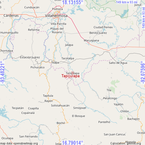
Tapijulapa GPS coordinates[2]
17° 27' 43.488" North, 92° 46' 44.688" West
| Map corner | latitude | longitude |
|---|---|---|
| Upper-left | 18.13155°, | -93.48221° |
| Center: | 17.46208°, | -92.77908° |
| Lower-right: | 16.79014°, | -92.07596° |
| Map W x H: | 149.2×149.2 km | = 92.7×92.7mi |
| max Lat: | 32.7° ⇑83.5% North |
| Tapijulapa: | 17.46208° |
| min Lat: | ⇓16.5% South 14.53588° |
| min Long | Tapijulapa | max Long |
| -117.105° | -92.77908° | -86.73105° |
| W 90%⇐ | ⇒10% E |
Elevation
Elevation of Tapijulapa is 54 m = 177 ft, and this is 1199.7 m = 3936 ft below average elevation for this country.
| Max E: |
3497 m = 11473 ft | 83.6% |
| Avg. | 1253.7 m = 4113 ft | |
| Tapijulapa | 54 m = 177 ft | |
Min E: |
-1 m = -3 ft | 16.4% |
See also: Mexico elevation on elevation.city.
Geographical zone
Tapijulapa is located in North Torrid zone (between Equator and Tropic of Cancer). Distance of this Northern Tropic circle is 664.3 km =412.8 mi to North.| Distance of | km | miles | from Tapijulapa |
|---|---|---|---|
| North Pole | 8065.5 | 5011.7 | to North |
| Arctic Circle | 5459.6 | 3392.4 | to North |
| Tropic Cancer | 664.3 | 412.8 | to North |
| Equator | 1941.6 | 1206.5 | to South |


Nearby cities:
15 places around Tapijulapa: (largest is in red/bold)
• Amatán
10.6 km =6.6 mi,  203°
203°
• Cuauhtémoc Barreal
7.1 km =4.4 mi,  123°
123°
• Cuitláhuac
12.7 km =7.9 mi,  156°
156°
• El Bebedero
15.6 km =9.7 mi, 117°
• Francisco I. Madero
15 km =9.3 mi,  261°
261°
• Guadalupe Victoria
14.3 km =8.9 mi,  223°
223°
• Jesús Carranza
14.3 km =8.9 mi,  113°
113°
• Libertad
8.9 km =5.5 mi,  130°
130°
• Oxolotán
9.7 km =6 mi, 161°
• Puxcatán
9.8 km =6.1 mi,  97°
97°
• Raya Zaragoza
11.8 km =7.3 mi, 122°
• Reforma y Planada
12.4 km =7.7 mi,  227°
227°
• San Ramón
13.3 km =8.3 mi,  342°
342°
• Xicoténcatl
10.1 km =6.3 mi,  51°
51°
• Zunu y Patastal
3.8 km =2.4 mi,  290°
290°
Sources, notices
• [Note1] Compared only with cities in Mexico existing in our database
• [Src1] Map data: © OpenStreetMap contributors (CC-BY-SA)
• [Src2] Other city data from geonames.org with taken over terms of usage.
• [Src3] Geographical zone / Annual Mean Temperature by Robert A. Rohde @ Wikipedia
