Vicente Guerrero geodata
Vicente Guerrero (Tabasco) is a populated place; located in Mexico in America/Mexico_City (GMT-6) time zone. With population of 1,572 people, there are 5495 cities with bigger population in this country. Compared to other cities in Mexico, 83% of cities are located further ↑North; 89.1% of cities are located further ←West and 80.5% of cities have higher elevation than Vicente Guerrero. Note1


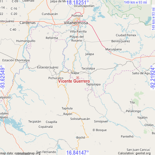
Vicente Guerrero GPS coordinates[2]
17° 30' 47.628" North, 92° 55' 20.496" West
| Map corner | latitude | longitude |
|---|---|---|
| Upper-left | 18.18251°, | -93.62549° |
| Center: | 17.51323°, | -92.92236° |
| Lower-right: | 16.84147°, | -92.21924° |
| Map W x H: | 149.1×149.1 km | = 92.6×92.6mi |
| max Lat: | 32.7° ⇑83% North |
| Vicente Guerrero: | 17.51323° |
| min Lat: | ⇓17% South 14.53588° |
| min Long | Vicente Guerrer | max Long |
| -117.105° | -92.92236° | -86.73105° |
| W 89.1%⇐ | ⇒10.9% E |
Elevation
Elevation of Vicente Guerrero is 87 m = 285 ft, and this is 1166.7 m = 3828 ft below average elevation for this country.
| Max E: |
3497 m = 11473 ft | 80.5% |
| Avg. | 1253.7 m = 4113 ft | |
| Vicente Guerrero | 87 m = 285 ft | |
Min E: |
-1 m = -3 ft | 19.5% |
See also: Mexico elevation on elevation.city.
Geographical zone
Vicente Guerrero is located in North Torrid zone (between Equator and Tropic of Cancer). Distance of this Northern Tropic circle is 658.6 km =409.2 mi to North.| Distance of | km | miles | from Vicente Guerrero |
|---|---|---|---|
| North Pole | 8059.8 | 5008.1 | to North |
| Arctic Circle | 5453.9 | 3388.9 | to North |
| Tropic Cancer | 658.6 | 409.2 | to North |
| Equator | 1947.3 | 1210 | to South |


Nearby cities:
15 places around Vicente Guerrero: (largest is in red/bold)
• Ceiba 2da. Sección (San Luis)
11.4 km =7.1 mi,  42°
42°
• Chapultepec
7.8 km =4.8 mi,  316°
316°
• Colonia Municipal
10.7 km =6.6 mi,  325°
325°
• Eureka y Belén
5.2 km =3.2 mi,  352°
352°
• Francisco I. Madero
8 km =5 mi,  177°
177°
• Ignacio Allende 2da. Sección
8.2 km =5.1 mi,  301°
301°
• Ixtapangajoya
8.6 km =5.3 mi,  258°
258°
• José María Morelos y Pavón (Las Delicias)
13.8 km =8.6 mi, 354°
• La Gloria
8.6 km =5.3 mi,  202°
202°
• Manuel Buelta 2da. Sección
8.5 km =5.3 mi, 328°
• Mariano Abasolo
6.2 km =3.9 mi,  307°
307°
• San Ramón
13.2 km =8.2 mi,  57°
57°
• Tacotalpa
13.8 km =8.6 mi,  47°
47°
• Teapa
5.1 km =3.2 mi, 322°
• Zunu y Patastal
12.4 km =7.7 mi,  110°
110°
Sources, notices
• [Note1] Compared only with cities in Mexico existing in our database
• [Src1] Map data: © OpenStreetMap contributors (CC-BY-SA)
• [Src2] Other city data from geonames.org with taken over terms of usage.
• [Src3] Geographical zone / Annual Mean Temperature by Robert A. Rohde @ Wikipedia
