Eureka y Belén geodata
Eureka y Belén (Tabasco) is a populated place; located in Mexico in America/Mexico_City (GMT-6) time zone. With population of 1,517 people, there are 5684 cities with bigger population in this country. Compared to other cities in Mexico, 82.5% of cities are located further ↑North; 89.1% of cities are located further ←West and 83.9% of cities have higher elevation than Eureka y Belén. Note1


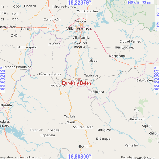
Eureka y Belén GPS coordinates[2]
17° 33' 34.848" North, 92° 55' 44.364" West
| Map corner | latitude | longitude |
|---|---|---|
| Upper-left | 18.22879°, | -93.63212° |
| Center: | 17.55968°, | -92.92899° |
| Lower-right: | 16.88809°, | -92.22587° |
| Map W x H: | 149.1×149.1 km | = 92.6×92.6mi |
| max Lat: | 32.7° ⇑82.5% North |
| Eureka y Belén: | 17.55968° |
| min Lat: | ⇓17.5% South 14.53588° |
| min Long | Eureka y Belén | max Long |
| -117.105° | -92.92899° | -86.73105° |
| W 89.1%⇐ | ⇒10.9% E |
Elevation
Elevation of Eureka y Belén is 52 m = 171 ft, and this is 1201.7 m = 3943 ft below average elevation for this country.
| Max E: |
3497 m = 11473 ft | 83.9% |
| Avg. | 1253.7 m = 4113 ft | |
| Eureka y Belén | 52 m = 171 ft | |
Min E: |
-1 m = -3 ft | 16.1% |
See also: Mexico elevation on elevation.city.
Geographical zone
Eureka y Belén is located in North Torrid zone (between Equator and Tropic of Cancer). Distance of this Northern Tropic circle is 653.5 km =406.1 mi to North.| Distance of | km | miles | from Eureka y Belén |
|---|---|---|---|
| North Pole | 8054.6 | 5004.9 | to North |
| Arctic Circle | 5448.7 | 3385.7 | to North |
| Tropic Cancer | 653.5 | 406.1 | to North |
| Equator | 1952.5 | 1213.2 | to South |


Nearby cities:
15 places around Eureka y Belén: (largest is in red/bold)
• Ceiba 2da. Sección (San Luis)
9.1 km =5.7 mi,  69°
69°
• Chapultepec
4.7 km =2.9 mi,  277°
277°
• Colonia Municipal
6.5 km =4 mi,  303°
303°
• Francisco I. Madero
13.2 km =8.2 mi,  175°
175°
• Ignacio Allende 2da. Sección
6.3 km =3.9 mi,  262°
262°
• Ixtapangajoya
10.3 km =6.4 mi,  228°
228°
• José María Morelos y Pavón (Las Delicias)
8.6 km =5.3 mi,  356°
356°
• Juan Aldama
11.9 km =7.4 mi, 297°
• La Gloria
13.3 km =8.3 mi,  191°
191°
• Manuel Buelta 2da. Sección
4.3 km =2.7 mi, 299°
• Mariano Abasolo
4.5 km =2.8 mi,  251°
251°
• San Ramón
12 km =7.5 mi,  81°
81°
• Tacotalpa
11.7 km =7.3 mi, 69°
• Teapa
2.7 km =1.7 mi, 245°
• Vicente Guerrero
5.2 km =3.2 mi,  172°
172°
Sources, notices
• [Note1] Compared only with cities in Mexico existing in our database
• [Src1] Map data: © OpenStreetMap contributors (CC-BY-SA)
• [Src2] Other city data from geonames.org with taken over terms of usage.
• [Src3] Geographical zone / Annual Mean Temperature by Robert A. Rohde @ Wikipedia
