Santa Cruz Ozolotepec geodata
Santa Cruz Ozolotepec (Oaxaca) is a populated place; located in Mexico in America/Mexico_City (GMT-6) time zone. With population of 1,090 people, there are 7984 cities with bigger population in this country. Compared to other cities in Mexico, 97% of cities are located further ↑North; 80.9% of cities are located further ←West and 50.6% of cities have lower elevation than Santa Cruz Ozolotepec. Note1


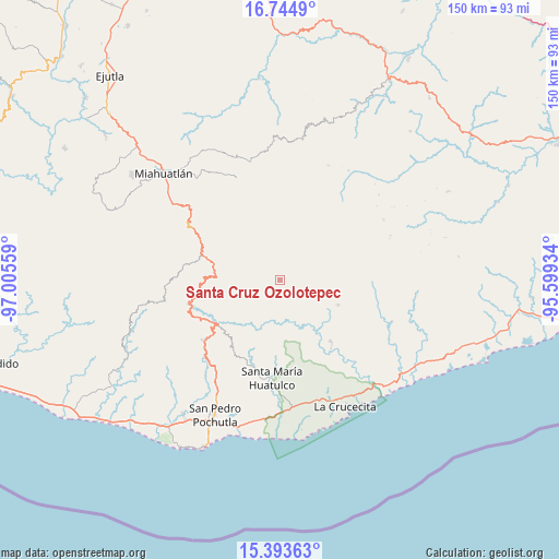
Santa Cruz Ozolotepec GPS coordinates[2]
16° 4' 13.476" North, 96° 18' 8.856" West
| Map corner | latitude | longitude |
|---|---|---|
| Upper-left | 16.7449°, | -97.00559° |
| Center: | 16.07041°, | -96.30246° |
| Lower-right: | 15.39363°, | -95.59934° |
| Map W x H: | 150.2×150.2 km | = 93.3×93.3mi |
| max Lat: | 32.7° ⇑97% North |
| Santa Cruz Ozolotepec: | 16.07041° |
| min Lat: | ⇓3% South 14.53588° |
| min Long | Santa Cruz Ozol | max Long |
| -117.105° | -96.30246° | -86.73105° |
| W 80.9%⇐ | ⇒19.1% E |
Elevation
Elevation of Santa Cruz Ozolotepec is 1465 m = 4806 ft, and this is 211.3 m = 693 ft above average elevation for this country.
| Max E: |
3497 m = 11473 ft | 49.4% |
| Santa Cruz Ozolotepec | 1465 m 4806 ft | |
| Avg. | 1253.7 m = 4113 ft | |
Min E: |
-1 m = -3 ft | 50.6% |
See also: Mexico elevation on elevation.city.
Geographical zone
Santa Cruz Ozolotepec is located in North Torrid zone (between Equator and Tropic of Cancer). Distance of this Northern Tropic circle is 819.1 km =509 mi to North.| Distance of | km | miles | from Santa Cruz Ozolotepec |
|---|---|---|---|
| North Pole | 8220.2 | 5107.8 | to North |
| Arctic Circle | 5614.3 | 3488.6 | to North |
| Tropic Cancer | 819.1 | 509 | to North |
| Equator | 1786.9 | 1110.3 | to South |


Nearby cities:
15 places around Santa Cruz Ozolotepec: (largest is in red/bold)
• Cieneguilla
15.3 km =9.5 mi,  324°
324°
• San Andrés Lovene
11.1 km =6.9 mi,  107°
107°
• San Felipe Lachilló
17.1 km =10.6 mi, 112°
• San Francisco Ozolotepec
9.3 km =5.8 mi,  68°
68°
• San Gregorio Ozolotepec
7.4 km =4.6 mi,  336°
336°
• San Juan Guivini
12 km =7.5 mi, 74°
• San Juan Ozolotepec
8.4 km =5.2 mi,  33°
33°
• San Marcial Ozolotepec
11.2 km =7 mi,  280°
280°
• San Mateo Piñas
8.5 km =5.3 mi,  203°
203°
• San Mateo Río Hondo
17.5 km =10.9 mi,  298°
298°
• San Miguel Suchixtepec
17.9 km =11.1 mi, 278°
• Santa María Ozolotepec
10.1 km =6.3 mi,  313°
313°
• Santiago Lapaguía
13.9 km =8.6 mi,  58°
58°
• Santiago Xanica
10.7 km =6.6 mi,  128°
128°
• Santo Domingo Ozolotepec
8.9 km =5.5 mi,  354°
354°
Sources, notices
• [Note1] Compared only with cities in Mexico existing in our database
• [Src1] Map data: © OpenStreetMap contributors (CC-BY-SA)
• [Src2] Other city data from geonames.org with taken over terms of usage.
• [Src3] Geographical zone / Annual Mean Temperature by Robert A. Rohde @ Wikipedia
