Tlachichilco geodata
Tlachichilco (Oaxaca) is a seat of a second-order administrative division; located in Mexico in America/Mexico_City (GMT-6) time zone. With population of 725 people, there are 12042 cities with bigger population in this country. Compared to other cities in Mexico, 82% of cities are located further ↑North; 59.4% of cities are located further ←West and 52.2% of cities have higher elevation than Tlachichilco. Note1


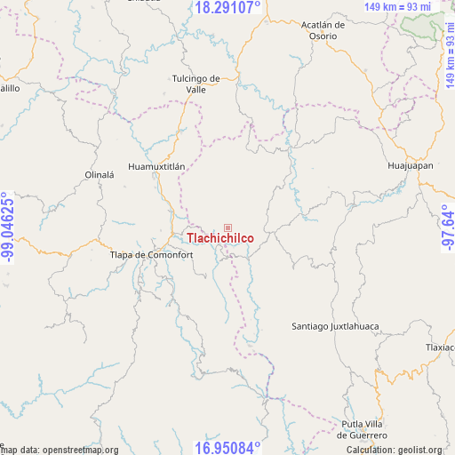
Tlachichilco GPS coordinates[2]
17° 37' 19.92" North, 98° 20' 35.232" West
| Map corner | latitude | longitude |
|---|---|---|
| Upper-left | 18.29107°, | -99.04625° |
| Center: | 17.6222°, | -98.34312° |
| Lower-right: | 16.95084°, | -97.64° |
| Map W x H: | 149×149 km | = 92.6×92.6mi |
| max Lat: | 32.7° ⇑82% North |
| Tlachichilco: | 17.6222° |
| min Lat: | ⇓18% South 14.53588° |
| min Long | Tlachichilco | max Long |
| -117.105° | -98.34312° | -86.73105° |
| W 59.4%⇐ | ⇒40.6% E |
Elevation
Elevation of Tlachichilco is 1327 m = 4354 ft, and this is 73.3 m = 240 ft above average elevation for this country.
| Max E: |
3497 m = 11473 ft | 52.2% |
| Tlachichilco | 1327 m 4354 ft | |
| Avg. | 1253.7 m = 4113 ft | |
Min E: |
-1 m = -3 ft | 47.8% |
See also: Mexico elevation on elevation.city.
Geographical zone
Tlachichilco is located in North Torrid zone (between Equator and Tropic of Cancer). Distance of this Northern Tropic circle is 646.5 km =401.7 mi to North.| Distance of | km | miles | from Tlachichilco |
|---|---|---|---|
| North Pole | 8047.7 | 5000.6 | to North |
| Arctic Circle | 5441.8 | 3381.4 | to North |
| Tropic Cancer | 646.5 | 401.7 | to North |
| Equator | 1959.4 | 1217.5 | to South |


Nearby cities:
15 places around Tlachichilco: (largest is in red/bold)
• Ahuehuetitlán
6 km =3.7 mi,  23°
23°
• Calihualá
12.2 km =7.6 mi,  145°
145°
• Cuyuxtlahuaca
15.6 km =9.7 mi,  180°
180°
• La Luz de Juárez
9.7 km =6 mi, 183°
• San Juan Ihualtepec
14.3 km =8.9 mi, 23°
• San Mateo Nejápam
8.6 km =5.3 mi,  295°
295°
• Santa Cruz
11.7 km =7.3 mi,  212°
212°
• Santa Cruz de Bravo
13.5 km =8.4 mi,  109°
109°
• Tamazola
14 km =8.7 mi,  67°
67°
• Tecoyame de Guadalupe
11.6 km =7.2 mi,  270°
270°
• Tepetlapa
7.1 km =4.4 mi,  313°
313°
• Tlalixtaquilla
5.7 km =3.5 mi, 206°
• Xonacatlán
15.2 km =9.4 mi, 208°
• Yucuyachi
15.6 km =9.7 mi,  95°
95°
• Zapotitlán Lagunas
15.7 km =9.8 mi,  341°
341°
Sources, notices
• [Note1] Compared only with cities in Mexico existing in our database
• [Src1] Map data: © OpenStreetMap contributors (CC-BY-SA)
• [Src2] Other city data from geonames.org with taken over terms of usage.
• [Src3] Geographical zone / Annual Mean Temperature by Robert A. Rohde @ Wikipedia
