Tecoyame de Guadalupe geodata
Tecoyame de Guadalupe (Guerrero) is a populated place; located in Mexico in America/Mexico_City (GMT-6) time zone. With population of 594 people, there are 14476 cities with bigger population in this country. Compared to other cities in Mexico, 82% of cities are located further ↑North; 57.9% of cities are located further ←West and 50.3% of cities have higher elevation than Tecoyame de Guadalupe. Note1


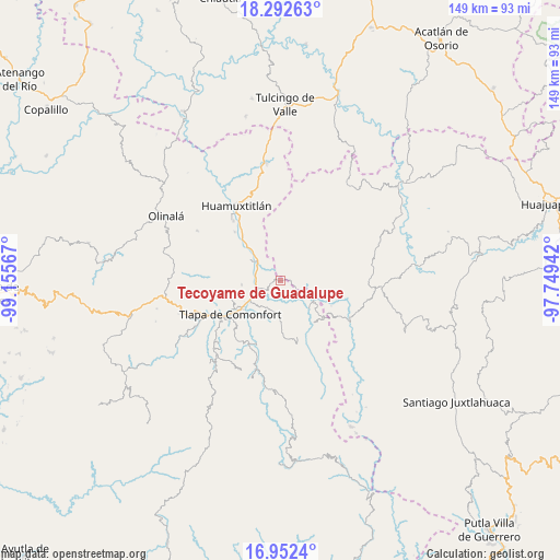
Tecoyame de Guadalupe GPS coordinates[2]
17° 37' 25.536" North, 98° 27' 9.144" West
| Map corner | latitude | longitude |
|---|---|---|
| Upper-left | 18.29263°, | -99.15567° |
| Center: | 17.62376°, | -98.45254° |
| Lower-right: | 16.9524°, | -97.74942° |
| Map W x H: | 149×149 km | = 92.6×92.6mi |
| max Lat: | 32.7° ⇑82% North |
| Tecoyame de Guadalupe: | 17.62376° |
| min Lat: | ⇓18% South 14.53588° |
| min Long | Tecoyame de Gua | max Long |
| -117.105° | -98.45254° | -86.73105° |
| W 57.9%⇐ | ⇒42.1% E |
Elevation
Elevation of Tecoyame de Guadalupe is 1416 m = 4646 ft, and this is 162.3 m = 532 ft above average elevation for this country.
| Max E: |
3497 m = 11473 ft | 50.3% |
| Tecoyame de Guadalupe | 1416 m 4646 ft | |
| Avg. | 1253.7 m = 4113 ft | |
Min E: |
-1 m = -3 ft | 49.7% |
See also: Mexico elevation on elevation.city.
Geographical zone
Tecoyame de Guadalupe is located in North Torrid zone (between Equator and Tropic of Cancer). Distance of this Northern Tropic circle is 646.3 km =401.6 mi to North.| Distance of | km | miles | from Tecoyame de Guadalupe |
|---|---|---|---|
| North Pole | 8047.5 | 5000.5 | to North |
| Arctic Circle | 5441.6 | 3381.3 | to North |
| Tropic Cancer | 646.3 | 401.6 | to North |
| Equator | 1959.6 | 1217.6 | to South |


Nearby cities:
15 places around Tecoyame de Guadalupe: (largest is in red/bold)
• Ahuatepec Pueblo
14.7 km =9.1 mi,  262°
262°
• Alpoyeca
8 km =5 mi,  310°
310°
• Atlamajac
12.6 km =7.8 mi,  232°
232°
• Ixcateopan
6.5 km =4 mi, 264°
• La Luz de Juárez
14.8 km =9.2 mi,  131°
131°
• San José Buenavista
9.5 km =5.9 mi, 305°
• San Mateo Nejápam
5.2 km =3.2 mi,  46°
46°
• San Pedro Aytec
11.3 km =7 mi,  316°
316°
• Santa Cruz
11.4 km =7.1 mi,  152°
152°
• Tepetlapa
8 km =5 mi, 53°
• Tlachichilco
11.6 km =7.2 mi,  90°
90°
• Tlalixtaquilla
10.4 km =6.5 mi,  120°
120°
• Tlalquetzala
12.9 km =8 mi, 315°
• Tlatzala
10.3 km =6.4 mi, 264°
• Xonacatlán
14.2 km =8.8 mi,  162°
162°
Sources, notices
• [Note1] Compared only with cities in Mexico existing in our database
• [Src1] Map data: © OpenStreetMap contributors (CC-BY-SA)
• [Src2] Other city data from geonames.org with taken over terms of usage.
• [Src3] Geographical zone / Annual Mean Temperature by Robert A. Rohde @ Wikipedia
