Tepetlapa geodata
Tepetlapa (Oaxaca) is a seat of a second-order administrative division; located in Mexico in America/Mexico_City (GMT-6) time zone. With population of 475 people, there are 16824 cities with bigger population in this country. Compared to other cities in Mexico, 81.6% of cities are located further ↑North; 58.7% of cities are located further ←West and 50.8% of cities have lower elevation than Tepetlapa. Note1


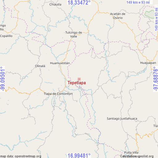
Tepetlapa GPS coordinates[2]
17° 39' 57.636" North, 98° 23' 30.768" West
| Map corner | latitude | longitude |
|---|---|---|
| Upper-left | 18.33472°, | -99.09501° |
| Center: | 17.66601°, | -98.39188° |
| Lower-right: | 16.99481°, | -97.68876° |
| Map W x H: | 149×149 km | = 92.6×92.6mi |
| max Lat: | 32.7° ⇑81.6% North |
| Tepetlapa: | 17.66601° |
| min Lat: | ⇓18.4% South 14.53588° |
| min Long | Tepetlapa | max Long |
| -117.105° | -98.39188° | -86.73105° |
| W 58.7%⇐ | ⇒41.3% E |
Elevation
Elevation of Tepetlapa is 1476 m = 4843 ft, and this is 222.3 m = 729 ft above average elevation for this country.
| Max E: |
3497 m = 11473 ft | 49.2% |
| Tepetlapa | 1476 m 4843 ft | |
| Avg. | 1253.7 m = 4113 ft | |
Min E: |
-1 m = -3 ft | 50.8% |
See also: Mexico elevation on elevation.city.
Geographical zone
Tepetlapa is located in North Torrid zone (between Equator and Tropic of Cancer). Distance of this Northern Tropic circle is 641.6 km =398.7 mi to North.| Distance of | km | miles | from Tepetlapa |
|---|---|---|---|
| North Pole | 8042.8 | 4997.6 | to North |
| Arctic Circle | 5436.9 | 3378.3 | to North |
| Tropic Cancer | 641.6 | 398.7 | to North |
| Equator | 1964.3 | 1220.6 | to South |


Nearby cities:
15 places around Tepetlapa: (largest is in red/bold)
• Ahuehuetitlán
7.6 km =4.7 mi,  85°
85°
• Alpoyeca
12.5 km =7.8 mi,  272°
272°
• Guadalupe del Recreo
16.2 km =10.1 mi,  22°
22°
• Ixcateopan
14 km =8.7 mi,  247°
247°
• La Luz de Juárez
15.3 km =9.5 mi,  162°
162°
• San José Buenavista
14.2 km =8.8 mi, 273°
• San Juan Ihualtepec
13.7 km =8.5 mi,  52°
52°
• San Mateo Nejápam
2.8 km =1.7 mi, 247°
• San Pedro Aytec
14.7 km =9.1 mi,  283°
283°
• Santa Cruz
14.8 km =9.2 mi,  184°
184°
• Tecoyame de Guadalupe
8 km =5 mi,  233°
233°
• Tlachichilco
7.1 km =4.4 mi,  133°
133°
• Tlalixtaquilla
10.3 km =6.4 mi,  165°
165°
• Tlalquetzala
16.2 km =10.1 mi,  285°
285°
• Zapotitlán Lagunas
10 km =6.2 mi,  1°
1°
Sources, notices
• [Note1] Compared only with cities in Mexico existing in our database
• [Src1] Map data: © OpenStreetMap contributors (CC-BY-SA)
• [Src2] Other city data from geonames.org with taken over terms of usage.
• [Src3] Geographical zone / Annual Mean Temperature by Robert A. Rohde @ Wikipedia
