El Macayal geodata
El Macayal (Veracruz) is a populated place; located in Mexico in America/Mexico_City (GMT-6) time zone. With population of 549 people, there are 15509 cities with bigger population in this country. Compared to other cities in Mexico, 81.8% of cities are located further ↑North; 85.2% of cities are located further ←West and 92.5% of cities have higher elevation than El Macayal. Note1


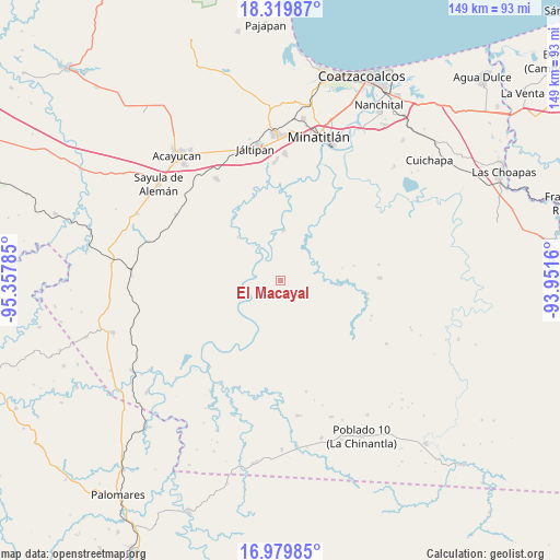
El Macayal GPS coordinates[2]
17° 39' 3.996" North, 94° 39' 16.992" West
| Map corner | latitude | longitude |
|---|---|---|
| Upper-left | 18.31987°, | -95.35785° |
| Center: | 17.65111°, | -94.65472° |
| Lower-right: | 16.97985°, | -93.9516° |
| Map W x H: | 149×149 km | = 92.6×92.6mi |
| max Lat: | 32.7° ⇑81.8% North |
| El Macayal: | 17.65111° |
| min Lat: | ⇓18.2% South 14.53588° |
| min Long | El Macayal | max Long |
| -117.105° | -94.65472° | -86.73105° |
| W 85.2%⇐ | ⇒14.8% E |
Elevation
Elevation of El Macayal is 18 m = 59 ft, and this is 1235.7 m = 4054 ft below average elevation for this country.
| Max E: |
3497 m = 11473 ft | 92.5% |
| Avg. | 1253.7 m = 4113 ft | |
| El Macayal | 18 m = 59 ft | |
Min E: |
-1 m = -3 ft | 7.5% |
See also: Mexico elevation on elevation.city.
Geographical zone
El Macayal is located in North Torrid zone (between Equator and Tropic of Cancer). Distance of this Northern Tropic circle is 643.3 km =399.7 mi to North.| Distance of | km | miles | from El Macayal |
|---|---|---|---|
| North Pole | 8044.4 | 4998.6 | to North |
| Arctic Circle | 5438.6 | 3379.4 | to North |
| Tropic Cancer | 643.3 | 399.7 | to North |
| Equator | 1962.6 | 1219.5 | to South |


Nearby cities:
15 places around El Macayal: (largest is in red/bold)
• Cahuapan (Anexo Niños Héroes)
24.6 km =15.3 mi,  153°
153°
• El Tepache
24.3 km =15.1 mi,  226°
226°
• Emilio Carranza (Salinas)
20 km =12.4 mi,  31°
31°
• Hidalgotitlán
13.3 km =8.3 mi,  3°
3°
• La Victoria
23.6 km =14.7 mi, 3°
• Las Lomas de Tacamichapan
24.6 km =15.3 mi,  346°
346°
• Licenciado Gabriel Ramos Millán
11.7 km =7.3 mi,  239°
239°
• Limonta
27.4 km =17 mi,  8°
8°
• Nuevo Atoyac
26.6 km =16.5 mi,  88°
88°
• San Carlos
6.4 km =4 mi,  301°
301°
• San Cristóbal
21.3 km =13.2 mi, 34°
• San Lorenzo Tenochtitlán
16.1 km =10 mi,  315°
315°
• Venustiano Carranza (Peña Blanca)
10.6 km =6.6 mi,  264°
264°
• Vicente Guerrero
18.6 km =11.6 mi,  201°
201°
• Villa Alta
12 km =7.5 mi, 241°
Sources, notices
• [Note1] Compared only with cities in Mexico existing in our database
• [Src1] Map data: © OpenStreetMap contributors (CC-BY-SA)
• [Src2] Other city data from geonames.org with taken over terms of usage.
• [Src3] Geographical zone / Annual Mean Temperature by Robert A. Rohde @ Wikipedia
