San Baltazar Atlimeyaya geodata
San Baltazar Atlimeyaya (Puebla) is a populated place; located in Mexico in America/Mexico_City (GMT-6) time zone. With population of 1,104 people, there are 7876 cities with bigger population in this country. Compared to other cities in Mexico, 64.9% of cities are located further ↑North; 57.5% of cities are located further ←West and 82.3% of cities have lower elevation than San Baltazar Atlimeyaya. Note1
Current local time in San Baltazar Atlimeyaya:
11:33 AM, MondayDifference from your time zone: hours


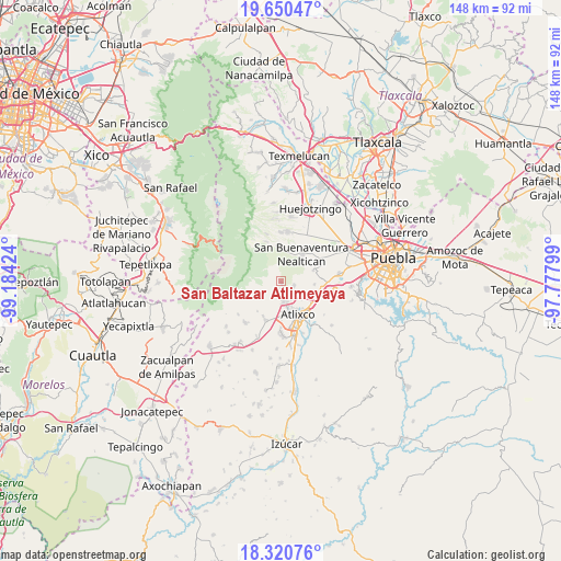
San Baltazar Atlimeyaya GPS coordinates[2]
18° 59' 12.984" North, 98° 28' 51.996" West
| Map corner | latitude | longitude |
|---|---|---|
| Upper-left | 19.65047°, | -99.18424° |
| Center: | 18.98694°, | -98.48111° |
| Lower-right: | 18.32076°, | -97.77799° |
| Map W x H: | 147.8×147.9 km | = 91.8×91.9mi |
| max Lat: | 32.7° ⇑64.9% North |
| San Baltazar Atlimeyaya: | 18.98694° |
| min Lat: | ⇓35.1% South 14.53588° |
| min Long | San Baltazar At | max Long |
| -117.105° | -98.48111° | -86.73105° |
| W 57.5%⇐ | ⇒42.5% E |
Elevation
Elevation of San Baltazar Atlimeyaya is 2196 m = 7205 ft, and this is 942.3 m = 3092 ft above average elevation for this country.
| Max E: |
3497 m = 11473 ft | 17.7% |
| San Baltazar Atlimeyaya | 2196 m 7205 ft | |
| Avg. | 1253.7 m = 4113 ft | |
Min E: |
-1 m = -3 ft | 82.3% |
See also: Mexico elevation on elevation.city.
Geographical zone
San Baltazar Atlimeyaya is located in North Torrid zone (between Equator and Tropic of Cancer). Distance of this Northern Tropic circle is 494.8 km =307.5 mi to North.| Distance of | km | miles | from San Baltazar Atlimeyaya |
|---|---|---|---|
| North Pole | 7895.9 | 4906.3 | to North |
| Arctic Circle | 5290 | 3287.1 | to North |
| Tropic Cancer | 494.8 | 307.5 | to North |
| Equator | 2111.1 | 1311.8 | to South |


Nearby cities:
15 places around San Baltazar Atlimeyaya: (largest is in red/bold)
• Atlixco
10 km =6.2 mi,  151°
151°
• Ciudad de Atlixco
10.2 km =6.3 mi, 154°
• Colonia Agrícola de Ocotepec (Colonia San José)
9.2 km =5.7 mi,  226°
226°
• El Encanto del Cerril
8.5 km =5.3 mi,  136°
136°
• Emiliano Zapata los Molinos
10.1 km =6.3 mi,  115°
115°
• Nealtican
9 km =5.6 mi,  38°
38°
• San Juan Ocotepec
9 km =5.6 mi, 230°
• San Martín Tlamapa
8.9 km =5.5 mi,  96°
96°
• San Martín Tlapala
3.2 km =2 mi,  133°
133°
• San Nicolás de los Ranchos
9.4 km =5.8 mi,  356°
356°
• San Pedro Benito Juárez
8.6 km =5.3 mi,  239°
239°
• San Pedro Yancuitlalpan
10.1 km =6.3 mi, 358°
• Santa Isabel Cholula
10.7 km =6.6 mi,  84°
84°
• Tecuanipan
9.2 km =5.7 mi,  71°
71°
• Tianguismanalco
3.6 km =2.2 mi,  109°
109°
Sources, notices
• [Note1] Compared only with cities in Mexico existing in our database
• [Src1] Map data: © OpenStreetMap contributors (CC-BY-SA)
• [Src2] Other city data from geonames.org with taken over terms of usage.
• [Src3] Geographical zone / Annual Mean Temperature by Robert A. Rohde @ Wikipedia
