Banzha geodata
Banzha (Hidalgo) is a populated place; located in Mexico in America/Mexico_City (GMT-6) time zone. With population of 725 people, there are 12042 cities with bigger population in this country. Compared to other cities in Mexico, 69.7% of cities are located further ↓South; 58.3% of cities are located further →East and 56.7% of cities have lower elevation than Banzha. Note1


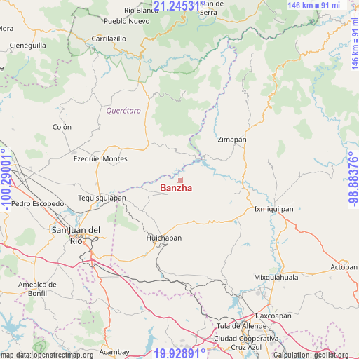
Banzha GPS coordinates[2]
20° 35' 18.708" North, 99° 35' 12.768" West
| Map corner | latitude | longitude |
|---|---|---|
| Upper-left | 21.24531°, | -100.29001° |
| Center: | 20.58853°, | -99.58688° |
| Lower-right: | 19.92891°, | -98.88376° |
| Map W x H: | 146.4×146.4 km | = 91×91mi |
| max Lat: | 32.7° ⇑30.3% North |
| Banzha: | 20.58853° |
| min Lat: | ⇓69.7% South 14.53588° |
| min Long | Banzha | max Long |
| -117.105° | -99.58688° | -86.73105° |
| W 41.7%⇐ | ⇒58.3% E |
Elevation
Elevation of Banzha is 1645 m = 5397 ft, and this is 391.3 m = 1284 ft above average elevation for this country.
| Max E: |
3497 m = 11473 ft | 43.3% |
| Banzha | 1645 m 5397 ft | |
| Avg. | 1253.7 m = 4113 ft | |
Min E: |
-1 m = -3 ft | 56.7% |
See also: Mexico elevation on elevation.city.
Geographical zone
Banzha is located in North Torrid zone (between Equator and Tropic of Cancer). Distance of this Northern Tropic circle is 316.7 km =196.8 mi to North.| Distance of | km | miles | from Banzha |
|---|---|---|---|
| North Pole | 7717.8 | 4795.6 | to North |
| Arctic Circle | 5111.9 | 3176.4 | to North |
| Tropic Cancer | 316.7 | 196.8 | to North |
| Equator | 2289.2 | 1422.4 | to South |


Nearby cities:
15 places around Banzha: (largest is in red/bold)
• Apartadero
10.1 km =6.3 mi,  161°
161°
• Bella Vista del Río
11.4 km =7.1 mi,  8°
8°
• Bomanxotha
11.6 km =7.2 mi,  225°
225°
• Boyecito
10.1 km =6.3 mi,  269°
269°
• El Riíto
4.7 km =2.9 mi,  254°
254°
• Gandhó
11.5 km =7.1 mi, 245°
• La Esquina
13.4 km =8.3 mi, 249°
• Pathé
12 km =7.5 mi,  275°
275°
• Pañhé
13.6 km =8.5 mi,  236°
236°
• San Antonio
14.3 km =8.9 mi, 243°
• San Miguel Caltepantla
12.4 km =7.7 mi,  197°
197°
• San Pedro
7.6 km =4.7 mi,  72°
72°
• Tecozautla
7.9 km =4.9 mi,  219°
219°
• Tenzabhí
10.7 km =6.6 mi,  209°
209°
• Uxdejhé
8.3 km =5.2 mi,  264°
264°
Sources, notices
• [Note1] Compared only with cities in Mexico existing in our database
• [Src1] Map data: © OpenStreetMap contributors (CC-BY-SA)
• [Src2] Other city data from geonames.org with taken over terms of usage.
• [Src3] Geographical zone / Annual Mean Temperature by Robert A. Rohde @ Wikipedia
