Zitlala geodata
Zitlala (Puebla) is a populated place; located in Mexico in America/Mexico_City (GMT-6) time zone. With population of 694 people, there are 12543 cities with bigger population in this country. Compared to other cities in Mexico, 57.7% of cities are located further ↓South; 67.7% of cities are located further ←West and 64.2% of cities have higher elevation than Zitlala. Note1


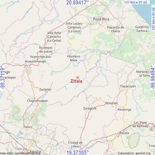
Zitlala GPS coordinates[2]
20° 2' 6" North, 97° 40' 5.016" West
| Map corner | latitude | longitude |
|---|---|---|
| Upper-left | 20.69417°, | -98.37119° |
| Center: | 20.035°, | -97.66806° |
| Lower-right: | 19.37305°, | -96.96494° |
| Map W x H: | 146.9×146.9 km | = 91.3×91.3mi |
| max Lat: | 32.7° ⇑42.3% North |
| Zitlala: | 20.035° |
| min Lat: | ⇓57.7% South 14.53588° |
| min Long | Zitlala | max Long |
| -117.105° | -97.66806° | -86.73105° |
| W 67.7%⇐ | ⇒32.3% E |
Elevation
Elevation of Zitlala is 737 m = 2418 ft, and this is 516.7 m = 1695 ft below average elevation for this country.
| Max E: |
3497 m = 11473 ft | 64.2% |
| Avg. | 1253.7 m = 4113 ft | |
| Zitlala | 737 m = 2418 ft | |
Min E: |
-1 m = -3 ft | 35.8% |
See also: Mexico elevation on elevation.city.
Geographical zone
Zitlala is located in North Torrid zone (between Equator and Tropic of Cancer). Distance of this Northern Tropic circle is 378.2 km =235 mi to North.| Distance of | km | miles | from Zitlala |
|---|---|---|---|
| North Pole | 7779.4 | 4833.9 | to North |
| Arctic Circle | 5173.5 | 3214.7 | to North |
| Tropic Cancer | 378.2 | 235 | to North |
| Equator | 2227.7 | 1384.2 | to South |


Nearby cities:
15 places around Zitlala: (largest is in red/bold)
• Atlequizayan
5.2 km =3.2 mi,  119°
119°
• Bibiano Hernández
6.3 km =3.9 mi,  329°
329°
• Caxhuacán
7.1 km =4.4 mi,  63°
63°
• Chilocoyo del Carmen
5.2 km =3.2 mi,  15°
15°
• Chipahuatlán
3.6 km =2.2 mi,  323°
323°
• Escatachuchut
3.9 km =2.4 mi,  54°
54°
• Hueytlalpan
3.1 km =1.9 mi,  253°
253°
• Ignacio Allende (Concepción)
4.4 km =2.7 mi,  127°
127°
• Ixtepec
2.6 km =1.6 mi, 116°
• Nanacatlán
3.6 km =2.2 mi,  193°
193°
• Ozelonacaxtla
5.8 km =3.6 mi,  77°
77°
• San Martín
4.1 km =2.5 mi,  137°
137°
• San Miguel del Progreso
5 km =3.1 mi,  178°
178°
• Tuxtla
4.1 km =2.5 mi,  160°
160°
• Zapotitlán
6 km =3.7 mi,  232°
232°
Sources, notices
• [Note1] Compared only with cities in Mexico existing in our database
• [Src1] Map data: © OpenStreetMap contributors (CC-BY-SA)
• [Src2] Other city data from geonames.org with taken over terms of usage.
• [Src3] Geographical zone / Annual Mean Temperature by Robert A. Rohde @ Wikipedia
