San Isidro Ochil geodata
San Isidro Ochil (Yucatán) is a populated place; located in Mexico in America/Merida (GMT-6) time zone. With population of 965 people, there are 9018 cities with bigger population in this country. Compared to other cities in Mexico, 70.7% of cities are located further ↓South; 98.4% of cities are located further ←West and 92.1% of cities have higher elevation than San Isidro Ochil. Note1


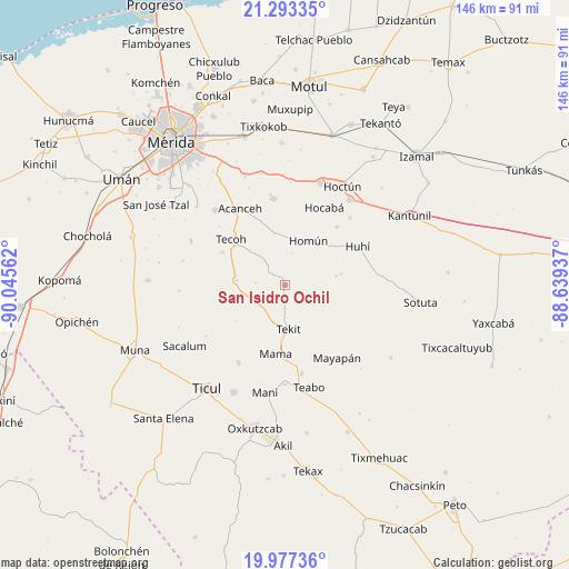
San Isidro Ochil GPS coordinates[2]
20° 38' 12.408" North, 89° 20' 32.964" West
| Map corner | latitude | longitude |
|---|---|---|
| Upper-left | 21.29335°, | -90.04562° |
| Center: | 20.63678°, | -89.34249° |
| Lower-right: | 19.97736°, | -88.63937° |
| Map W x H: | 146.3×146.3 km | = 90.9×90.9mi |
| max Lat: | 32.7° ⇑29.3% North |
| San Isidro Ochil: | 20.63678° |
| min Lat: | ⇓70.7% South 14.53588° |
| min Long | San Isidro Ochi | max Long |
| -117.105° | -89.34249° | -86.73105° |
| W 98.4%⇐ | ⇒1.6% E |
Elevation
Elevation of San Isidro Ochil is 19 m = 62 ft, and this is 1234.7 m = 4051 ft below average elevation for this country.
| Max E: |
3497 m = 11473 ft | 92.1% |
| Avg. | 1253.7 m = 4113 ft | |
| San Isidro Ochil | 19 m = 62 ft | |
Min E: |
-1 m = -3 ft | 7.9% |
See also: Mexico elevation on elevation.city.
Geographical zone
San Isidro Ochil is located in North Torrid zone (between Equator and Tropic of Cancer). Distance of this Northern Tropic circle is 311.3 km =193.4 mi to North.| Distance of | km | miles | from San Isidro Ochil |
|---|---|---|---|
| North Pole | 7712.5 | 4792.3 | to North |
| Arctic Circle | 5106.6 | 3173.1 | to North |
| Tropic Cancer | 311.3 | 193.4 | to North |
| Equator | 2294.6 | 1425.8 | to South |


Nearby cities:
15 places around San Isidro Ochil: (largest is in red/bold)
• Acanceh
22.7 km =14.1 mi,  329°
329°
• Chapab
23.1 km =14.4 mi,  211°
211°
• Cuzama
12 km =7.5 mi,  12°
12°
• Eknakan
13.7 km =8.5 mi,  348°
348°
• Hocaba
22.3 km =13.9 mi,  26°
26°
• Homun
12.9 km =8 mi, 27°
• Huhi
21.4 km =13.3 mi,  62°
62°
• Lepan
18.2 km =11.3 mi,  297°
297°
• Mama
17.7 km =11 mi,  187°
187°
• Mayapan
23 km =14.3 mi,  144°
144°
• Sanahcat
20.1 km =12.5 mi,  41°
41°
• Seyé
22.3 km =13.9 mi, 352°
• Tekit
11.4 km =7.1 mi,  175°
175°
• Tekoh
18.1 km =11.2 mi,  310°
310°
• Telchaquillo
12.7 km =7.9 mi,  275°
275°
Sources, notices
• [Note1] Compared only with cities in Mexico existing in our database
• [Src1] Map data: © OpenStreetMap contributors (CC-BY-SA)
• [Src2] Other city data from geonames.org with taken over terms of usage.
• [Src3] Geographical zone / Annual Mean Temperature by Robert A. Rohde @ Wikipedia
