Monte Grande geodata
Monte Grande (Veracruz) is a populated place; located in Mexico in America/Mexico_City (GMT-6) time zone. With population of 820 people, there are 10646 cities with bigger population in this country. Compared to other cities in Mexico, 56.3% of cities are located further ↑North; 74% of cities are located further ←West and 57.3% of cities have lower elevation than Monte Grande. Note1


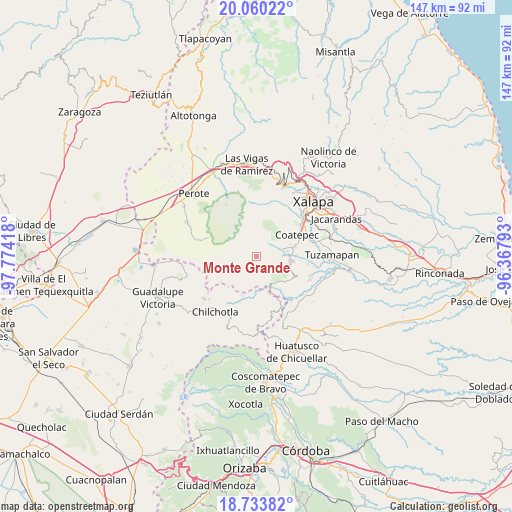
Monte Grande GPS coordinates[2]
19° 23' 54.132" North, 97° 4' 15.78" West
| Map corner | latitude | longitude |
|---|---|---|
| Upper-left | 20.06022°, | -97.77418° |
| Center: | 19.39837°, | -97.07105° |
| Lower-right: | 18.73382°, | -96.36793° |
| Map W x H: | 147.5×147.5 km | = 91.7×91.7mi |
| max Lat: | 32.7° ⇑56.3% North |
| Monte Grande: | 19.39837° |
| min Lat: | ⇓43.7% South 14.53588° |
| min Long | Monte Grande | max Long |
| -117.105° | -97.07105° | -86.73105° |
| W 74%⇐ | ⇒26% E |
Elevation
Elevation of Monte Grande is 1671 m = 5482 ft, and this is 417.3 m = 1369 ft above average elevation for this country.
| Max E: |
3497 m = 11473 ft | 42.7% |
| Monte Grande | 1671 m 5482 ft | |
| Avg. | 1253.7 m = 4113 ft | |
Min E: |
-1 m = -3 ft | 57.3% |
See also: Mexico elevation on elevation.city.
Geographical zone
Monte Grande is located in North Torrid zone (between Equator and Tropic of Cancer). Distance of this Northern Tropic circle is 449 km =279 mi to North.| Distance of | km | miles | from Monte Grande |
|---|---|---|---|
| North Pole | 7850.2 | 4877.9 | to North |
| Arctic Circle | 5244.3 | 3258.7 | to North |
| Tropic Cancer | 449 | 279 | to North |
| Equator | 2156.9 | 1340.2 | to South |


Nearby cities:
15 places around Monte Grande: (largest is in red/bold)
• Ayahualulco
9.7 km =6 mi,  237°
237°
• Barranca Nueva
7.6 km =4.7 mi,  153°
153°
• Baxtla
10.7 km =6.6 mi,  111°
111°
• Casa Quemada
9.4 km =5.8 mi,  142°
142°
• Cetlalpan
5.5 km =3.4 mi, 138°
• Colonia Úrsulo Galván
10.3 km =6.4 mi,  70°
70°
• Cosautlán
11.2 km =7 mi,  131°
131°
• Huehuetecpan
11.4 km =7.1 mi, 139°
• Ixhuacán de los Reyes
6.8 km =4.2 mi,  225°
225°
• Teocelo
10.3 km =6.4 mi,  97°
97°
• Texin
7.8 km =4.8 mi,  117°
117°
• Tlalchy
2.1 km =1.3 mi,  201°
201°
• Tonalaco
7.3 km =4.5 mi,  298°
298°
• Xico
7.1 km =4.4 mi, 68°
• Xocotepéc
11 km =6.8 mi,  251°
251°
Sources, notices
• [Note1] Compared only with cities in Mexico existing in our database
• [Src1] Map data: © OpenStreetMap contributors (CC-BY-SA)
• [Src2] Other city data from geonames.org with taken over terms of usage.
• [Src3] Geographical zone / Annual Mean Temperature by Robert A. Rohde @ Wikipedia
