Cetlalpan geodata
Cetlalpan (Veracruz) is a populated place; located in Mexico in America/Mexico_City (GMT-6) time zone. With population of 614 people, there are 14035 cities with bigger population in this country. Compared to other cities in Mexico, 57.3% of cities are located further ↑North; 74.4% of cities are located further ←West and 51.5% of cities have lower elevation than Cetlalpan. Note1


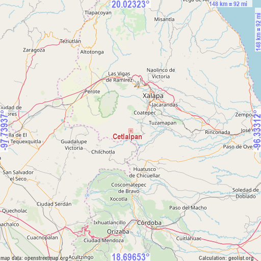
Cetlalpan GPS coordinates[2]
19° 21' 40.428" North, 97° 2' 10.464" West
| Map corner | latitude | longitude |
|---|---|---|
| Upper-left | 20.02323°, | -97.73937° |
| Center: | 19.36123°, | -97.03624° |
| Lower-right: | 18.69653°, | -96.33312° |
| Map W x H: | 147.5×147.5 km | = 91.7×91.7mi |
| max Lat: | 32.7° ⇑57.3% North |
| Cetlalpan: | 19.36123° |
| min Lat: | ⇓42.7% South 14.53588° |
| min Long | Cetlalpan | max Long |
| -117.105° | -97.03624° | -86.73105° |
| W 74.4%⇐ | ⇒25.6% E |
Elevation
Elevation of Cetlalpan is 1508 m = 4948 ft, and this is 254.3 m = 834 ft above average elevation for this country.
| Max E: |
3497 m = 11473 ft | 48.5% |
| Cetlalpan | 1508 m 4948 ft | |
| Avg. | 1253.7 m = 4113 ft | |
Min E: |
-1 m = -3 ft | 51.5% |
See also: Mexico elevation on elevation.city.
Geographical zone
Cetlalpan is located in North Torrid zone (between Equator and Tropic of Cancer). Distance of this Northern Tropic circle is 453.2 km =281.6 mi to North.| Distance of | km | miles | from Cetlalpan |
|---|---|---|---|
| North Pole | 7854.3 | 4880.4 | to North |
| Arctic Circle | 5248.4 | 3261.2 | to North |
| Tropic Cancer | 453.2 | 281.6 | to North |
| Equator | 2152.8 | 1337.7 | to South |


Nearby cities:
15 places around Cetlalpan: (largest is in red/bold)
• Barranca Nueva
2.7 km =1.7 mi,  186°
186°
• Baxtla
6.3 km =3.9 mi,  88°
88°
• Casa Quemada
3.9 km =2.4 mi,  148°
148°
• Cosautlán
5.8 km =3.6 mi,  124°
124°
• Emiliano Zapata
9.3 km =5.8 mi,  137°
137°
• Huehuetecpan
5.9 km =3.7 mi, 141°
• Ixhuacán de los Reyes
8.6 km =5.3 mi,  265°
265°
• Monte Grande
5.5 km =3.4 mi,  318°
318°
• Piedra Parada
8.1 km =5 mi,  101°
101°
• San Miguel Tlapéxcatl
7.9 km =4.9 mi, 143°
• Teocelo
7.1 km =4.4 mi,  67°
67°
• Texin
3.3 km =2.1 mi,  80°
80°
• Tlalchy
4.9 km =3 mi,  296°
296°
• Tlamoloaxtla
9.5 km =5.9 mi,  211°
211°
• Xico
7.3 km =4.5 mi,  23°
23°
Sources, notices
• [Note1] Compared only with cities in Mexico existing in our database
• [Src1] Map data: © OpenStreetMap contributors (CC-BY-SA)
• [Src2] Other city data from geonames.org with taken over terms of usage.
• [Src3] Geographical zone / Annual Mean Temperature by Robert A. Rohde @ Wikipedia
