Teocelo geodata
Teocelo (Veracruz) is a seat of a second-order administrative division; located in Mexico in America/Mexico_City (GMT-6) time zone. With population of 9,967 people, there are 955 cities with bigger population in this country. Compared to other cities in Mexico, 56.6% of cities are located further ↑North; 75.2% of cities are located further ←West and 55.2% of cities have higher elevation than Teocelo. Note1


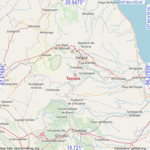
Teocelo GPS coordinates[2]
19° 23' 8.16" North, 96° 58' 25.356" West
| Map corner | latitude | longitude |
|---|---|---|
| Upper-left | 20.0475°, | -97.67684° |
| Center: | 19.3856°, | -96.97371° |
| Lower-right: | 18.721°, | -96.27059° |
| Map W x H: | 147.5×147.5 km | = 91.7×91.7mi |
| max Lat: | 32.7° ⇑56.6% North |
| Teocelo: | 19.3856° |
| min Lat: | ⇓43.4% South 14.53588° |
| min Long | Teocelo | max Long |
| -117.105° | -96.97371° | -86.73105° |
| W 75.2%⇐ | ⇒24.8% E |
Elevation
Elevation of Teocelo is 1189 m = 3901 ft, and this is 64.7 m = 212 ft below average elevation for this country.
| Max E: |
3497 m = 11473 ft | 55.2% |
| Avg. | 1253.7 m = 4113 ft | |
| Teocelo | 1189 m = 3901 ft | |
Min E: |
-1 m = -3 ft | 44.8% |
See also: Mexico elevation on elevation.city.
Geographical zone
Teocelo is located in North Torrid zone (between Equator and Tropic of Cancer). Distance of this Northern Tropic circle is 450.4 km =279.9 mi to North.| Distance of | km | miles | from Teocelo |
|---|---|---|---|
| North Pole | 7851.6 | 4878.8 | to North |
| Arctic Circle | 5245.7 | 3259.5 | to North |
| Tropic Cancer | 450.4 | 279.9 | to North |
| Equator | 2155.5 | 1339.4 | to South |


Nearby cities:
15 places around Teocelo: (largest is in red/bold)
• Baxtla
2.6 km =1.6 mi,  186°
186°
• Cetlalpan
7.1 km =4.4 mi,  247°
247°
• Coatepec
7.5 km =4.7 mi,  9°
9°
• Colonia Obrera (Las Puentes)
4.9 km =3 mi, 11°
• Colonia Úrsulo Galván
4.8 km =3 mi,  354°
354°
• Cosautlán
6.2 km =3.9 mi,  196°
196°
• Independencia
2.8 km =1.7 mi,  88°
88°
• Limones
7.5 km =4.7 mi,  134°
134°
• Mahuixtlan
6.5 km =4 mi,  65°
65°
• Monte Blanco
4.6 km =2.9 mi,  101°
101°
• Piedra Parada
4.6 km =2.9 mi,  161°
161°
• San Marcos de León
4.4 km =2.7 mi, 12°
• Texin
3.9 km =2.4 mi,  236°
236°
• Xico
5.4 km =3.4 mi,  318°
318°
• Zimpizahua
6 km =3.7 mi,  26°
26°
Sources, notices
• [Note1] Compared only with cities in Mexico existing in our database
• [Src1] Map data: © OpenStreetMap contributors (CC-BY-SA)
• [Src2] Other city data from geonames.org with taken over terms of usage.
• [Src3] Geographical zone / Annual Mean Temperature by Robert A. Rohde @ Wikipedia
