Baxtla geodata
Baxtla (Veracruz) is a populated place; located in Mexico in America/Mexico_City (GMT-6) time zone. With population of 695 people, there are 12521 cities with bigger population in this country. Compared to other cities in Mexico, 57.2% of cities are located further ↑North; 75.2% of cities are located further ←West and 56% of cities have higher elevation than Baxtla. Note1


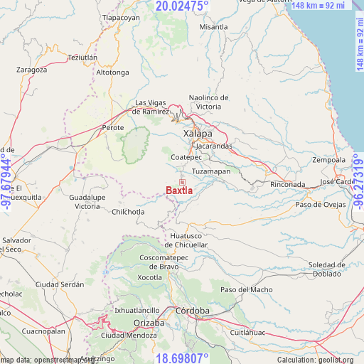
Baxtla GPS coordinates[2]
19° 21' 45.936" North, 96° 58' 34.716" West
| Map corner | latitude | longitude |
|---|---|---|
| Upper-left | 20.02475°, | -97.67944° |
| Center: | 19.36276°, | -96.97631° |
| Lower-right: | 18.69807°, | -96.27319° |
| Map W x H: | 147.5×147.5 km | = 91.7×91.7mi |
| max Lat: | 32.7° ⇑57.2% North |
| Baxtla: | 19.36276° |
| min Lat: | ⇓42.8% South 14.53588° |
| min Long | Baxtla | max Long |
| -117.105° | -96.97631° | -86.73105° |
| W 75.2%⇐ | ⇒24.8% E |
Elevation
Elevation of Baxtla is 1157 m = 3796 ft, and this is 96.7 m = 317 ft below average elevation for this country.
| Max E: |
3497 m = 11473 ft | 56% |
| Avg. | 1253.7 m = 4113 ft | |
| Baxtla | 1157 m = 3796 ft | |
Min E: |
-1 m = -3 ft | 44% |
See also: Mexico elevation on elevation.city.
Geographical zone
Baxtla is located in North Torrid zone (between Equator and Tropic of Cancer). Distance of this Northern Tropic circle is 453 km =281.5 mi to North.| Distance of | km | miles | from Baxtla |
|---|---|---|---|
| North Pole | 7854.1 | 4880.3 | to North |
| Arctic Circle | 5248.2 | 3261.1 | to North |
| Tropic Cancer | 453 | 281.5 | to North |
| Equator | 2152.9 | 1337.7 | to South |


Nearby cities:
15 places around Baxtla: (largest is in red/bold)
• Casa Quemada
5.5 km =3.4 mi,  230°
230°
• Cetlalpan
6.3 km =3.9 mi,  268°
268°
• Cosautlán
3.7 km =2.3 mi,  203°
203°
• Emiliano Zapata
7 km =4.3 mi,  180°
180°
• Huehuetecpan
5.4 km =3.4 mi,  208°
208°
• Independencia
4.1 km =2.5 mi,  50°
50°
• La Reforma
5.7 km =3.5 mi,  135°
135°
• Limones
6.2 km =3.9 mi,  116°
116°
• Monte Blanco
5.1 km =3.2 mi,  71°
71°
• Piedra Parada
2.5 km =1.6 mi, 136°
• San Marcos de León
6.9 km =4.3 mi,  10°
10°
• San Miguel Tlapéxcatl
6.7 km =4.2 mi,  193°
193°
• Teocelo
2.6 km =1.6 mi, 6°
• Texin
3 km =1.9 mi,  276°
276°
• Vaquería
5.5 km =3.4 mi,  156°
156°
Sources, notices
• [Note1] Compared only with cities in Mexico existing in our database
• [Src1] Map data: © OpenStreetMap contributors (CC-BY-SA)
• [Src2] Other city data from geonames.org with taken over terms of usage.
• [Src3] Geographical zone / Annual Mean Temperature by Robert A. Rohde @ Wikipedia
