Xico geodata
Xico (Veracruz) is a seat of a second-order administrative division; located in Mexico in America/Mexico_City (GMT-6) time zone. With population of 18,652 people, there are 527 cities with bigger population in this country. Compared to other cities in Mexico, 55.8% of cities are located further ↑North; 74.7% of cities are located further ←West and 52.4% of cities have higher elevation than Xico. Note1


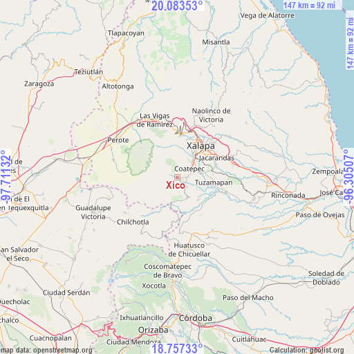
Xico GPS coordinates[2]
19° 25' 18.408" North, 97° 0' 29.484" West
| Map corner | latitude | longitude |
|---|---|---|
| Upper-left | 20.08353°, | -97.71132° |
| Center: | 19.42178°, | -97.00819° |
| Lower-right: | 18.75733°, | -96.30507° |
| Map W x H: | 147.5×147.5 km | = 91.7×91.7mi |
| max Lat: | 32.7° ⇑55.8% North |
| Xico: | 19.42178° |
| min Lat: | ⇓44.2% South 14.53588° |
| min Long | Xico | max Long |
| -117.105° | -97.00819° | -86.73105° |
| W 74.7%⇐ | ⇒25.3% E |
Elevation
Elevation of Xico is 1318 m = 4324 ft, and this is 64.3 m = 211 ft above average elevation for this country.
| Max E: |
3497 m = 11473 ft | 52.4% |
| Xico | 1318 m 4324 ft | |
| Avg. | 1253.7 m = 4113 ft | |
Min E: |
-1 m = -3 ft | 47.6% |
See also: Mexico elevation on elevation.city.
Geographical zone
Xico is located in North Torrid zone (between Equator and Tropic of Cancer). Distance of this Northern Tropic circle is 446.4 km =277.4 mi to North.| Distance of | km | miles | from Xico |
|---|---|---|---|
| North Pole | 7847.6 | 4876.3 | to North |
| Arctic Circle | 5241.7 | 3257 | to North |
| Tropic Cancer | 446.4 | 277.4 | to North |
| Equator | 2159.5 | 1341.9 | to South |


Nearby cities:
15 places around Xico: (largest is in red/bold)
• Baxtla
7.4 km =4.6 mi,  153°
153°
• Cetlalpan
7.3 km =4.5 mi,  203°
203°
• Cinco Palos
8.8 km =5.5 mi,  12°
12°
• Coatepec
6 km =3.7 mi,  55°
55°
• Colonia Obrera (Las Puentes)
4.7 km =2.9 mi,  80°
80°
• Colonia Úrsulo Galván
3.2 km =2 mi, 76°
• Cuauhtémoc
8.4 km =5.2 mi,  22°
22°
• Independencia
7.6 km =4.7 mi,  121°
121°
• La Orduña
8.3 km =5.2 mi,  66°
66°
• Monte Grande
7.1 km =4.4 mi,  248°
248°
• San Marcos de León
4.6 km =2.9 mi,  87°
87°
• Teocelo
5.4 km =3.4 mi,  138°
138°
• Texin
6.2 km =3.9 mi,  176°
176°
• Tlalchy
8.6 km =5.3 mi,  238°
238°
• Zimpizahua
6.5 km =4 mi, 78°
Sources, notices
• [Note1] Compared only with cities in Mexico existing in our database
• [Src1] Map data: © OpenStreetMap contributors (CC-BY-SA)
• [Src2] Other city data from geonames.org with taken over terms of usage.
• [Src3] Geographical zone / Annual Mean Temperature by Robert A. Rohde @ Wikipedia
