Mahuixtlan geodata
Mahuixtlan (Veracruz) is a populated place; located in Mexico in America/Mexico_City (GMT-6) time zone. With population of 3,794 people, there are 2409 cities with bigger population in this country. Compared to other cities in Mexico, 56.1% of cities are located further ↑North; 75.9% of cities are located further ←West and 60.4% of cities have higher elevation than Mahuixtlan. Note1


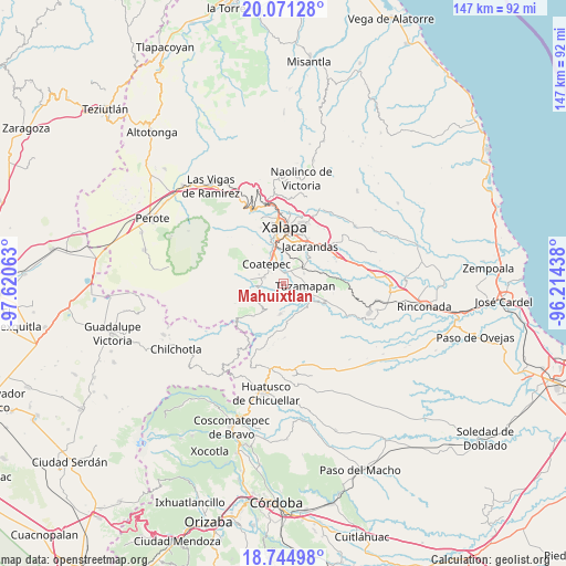
Mahuixtlan GPS coordinates[2]
19° 24' 34.128" North, 96° 55' 3" West
| Map corner | latitude | longitude |
|---|---|---|
| Upper-left | 20.07128°, | -97.62063° |
| Center: | 19.40948°, | -96.9175° |
| Lower-right: | 18.74498°, | -96.21438° |
| Map W x H: | 147.5×147.5 km | = 91.7×91.7mi |
| max Lat: | 32.7° ⇑56.1% North |
| Mahuixtlan: | 19.40948° |
| min Lat: | ⇓43.9% South 14.53588° |
| min Long | Mahuixtlan | max Long |
| -117.105° | -96.9175° | -86.73105° |
| W 75.9%⇐ | ⇒24.1% E |
Elevation
Elevation of Mahuixtlan is 979 m = 3212 ft, and this is 274.7 m = 901 ft below average elevation for this country.
| Max E: |
3497 m = 11473 ft | 60.4% |
| Avg. | 1253.7 m = 4113 ft | |
| Mahuixtlan | 979 m = 3212 ft | |
Min E: |
-1 m = -3 ft | 39.6% |
See also: Mexico elevation on elevation.city.
Geographical zone
Mahuixtlan is located in North Torrid zone (between Equator and Tropic of Cancer). Distance of this Northern Tropic circle is 447.8 km =278.2 mi to North.| Distance of | km | miles | from Mahuixtlan |
|---|---|---|---|
| North Pole | 7848.9 | 4877.1 | to North |
| Arctic Circle | 5243 | 3257.8 | to North |
| Tropic Cancer | 447.8 | 278.2 | to North |
| Equator | 2158.1 | 1341 | to South |


Nearby cities:
15 places around Mahuixtlan: (largest is in red/bold)
• Alborada
6.5 km =4 mi,  48°
48°
• Bella Esperanza
6 km =3.7 mi,  63°
63°
• Coatepec
6.6 km =4.1 mi,  315°
315°
• Colonia Obrera (Las Puentes)
5.3 km =3.3 mi,  293°
293°
• Colonia Úrsulo Galván
6.7 km =4.2 mi, 288°
• El Grande
2.7 km =1.7 mi,  3°
3°
• Independencia
4 km =2.5 mi,  229°
229°
• La Orduña
5 km =3.1 mi,  337°
337°
• Las Lomas
4.4 km =2.7 mi,  15°
15°
• Llano Grande
5.9 km =3.7 mi,  137°
137°
• Monte Blanco
3.8 km =2.4 mi,  200°
200°
• San Marcos de León
5.2 km =3.2 mi, 287°
• Teocelo
6.5 km =4 mi,  245°
245°
• Tuzamapan
5.7 km =3.5 mi,  97°
97°
• Zimpizahua
4.2 km =2.6 mi,  310°
310°
Sources, notices
• [Note1] Compared only with cities in Mexico existing in our database
• [Src1] Map data: © OpenStreetMap contributors (CC-BY-SA)
• [Src2] Other city data from geonames.org with taken over terms of usage.
• [Src3] Geographical zone / Annual Mean Temperature by Robert A. Rohde @ Wikipedia
