Zimpizahua geodata
Zimpizahua (Veracruz) is a populated place; located in Mexico in America/Mexico_City (GMT-6) time zone. With population of 758 people, there are 11551 cities with bigger population in this country. Compared to other cities in Mexico, 55.4% of cities are located further ↑North; 75.6% of cities are located further ←West and 57.6% of cities have higher elevation than Zimpizahua. Note1


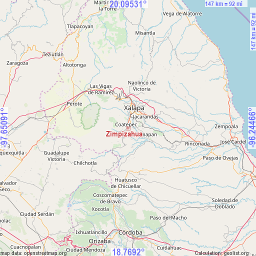
Zimpizahua GPS coordinates[2]
19° 26' 0.996" North, 96° 56' 52.008" West
| Map corner | latitude | longitude |
|---|---|---|
| Upper-left | 20.09531°, | -97.65091° |
| Center: | 19.43361°, | -96.94778° |
| Lower-right: | 18.7692°, | -96.24466° |
| Map W x H: | 147.4×147.5 km | = 91.6×91.7mi |
| max Lat: | 32.7° ⇑55.4% North |
| Zimpizahua: | 19.43361° |
| min Lat: | ⇓44.6% South 14.53588° |
| min Long | Zimpizahua | max Long |
| -117.105° | -96.94778° | -86.73105° |
| W 75.6%⇐ | ⇒24.4% E |
Elevation
Elevation of Zimpizahua is 1111 m = 3645 ft, and this is 142.7 m = 468 ft below average elevation for this country.
| Max E: |
3497 m = 11473 ft | 57.6% |
| Avg. | 1253.7 m = 4113 ft | |
| Zimpizahua | 1111 m = 3645 ft | |
Min E: |
-1 m = -3 ft | 42.4% |
See also: Mexico elevation on elevation.city.
Geographical zone
Zimpizahua is located in North Torrid zone (between Equator and Tropic of Cancer). Distance of this Northern Tropic circle is 445.1 km =276.6 mi to North.| Distance of | km | miles | from Zimpizahua |
|---|---|---|---|
| North Pole | 7846.2 | 4875.4 | to North |
| Arctic Circle | 5240.4 | 3256.2 | to North |
| Tropic Cancer | 445.1 | 276.6 | to North |
| Equator | 2160.8 | 1342.7 | to South |


Nearby cities:
15 places around Zimpizahua: (largest is in red/bold)
• Coatepec
2.5 km =1.6 mi,  325°
325°
• Colonia Obrera (Las Puentes)
1.8 km =1.1 mi,  253°
253°
• Colonia Úrsulo Galván
3.3 km =2.1 mi,  260°
260°
• El Grande
3.4 km =2.1 mi,  89°
89°
• Independencia
5.3 km =3.3 mi,  178°
178°
• La Laguna
5.6 km =3.5 mi,  15°
15°
• La Orduña
2.3 km =1.4 mi,  32°
32°
• Las Lomas
4.6 km =2.9 mi,  70°
70°
• Mahuixtlan
4.2 km =2.6 mi,  130°
130°
• Mariano Escobedo
7.1 km =4.4 mi,  2°
2°
• Monte Blanco
6.5 km =4 mi,  163°
163°
• Pacho Viejo
6.3 km =3.9 mi, 31°
• San Marcos de León
2.1 km =1.3 mi,  237°
237°
• Teocelo
6 km =3.7 mi,  206°
206°
• Xico
6.5 km =4 mi, 258°
Sources, notices
• [Note1] Compared only with cities in Mexico existing in our database
• [Src1] Map data: © OpenStreetMap contributors (CC-BY-SA)
• [Src2] Other city data from geonames.org with taken over terms of usage.
• [Src3] Geographical zone / Annual Mean Temperature by Robert A. Rohde @ Wikipedia
