El Grande geodata
El Grande (Veracruz) is a populated place; located in Mexico in America/Mexico_City (GMT-6) time zone. With population of 955 people, there are 9122 cities with bigger population in this country. Compared to other cities in Mexico, 55.4% of cities are located further ↑North; 76% of cities are located further ←West and 58.6% of cities have higher elevation than El Grande. Note1


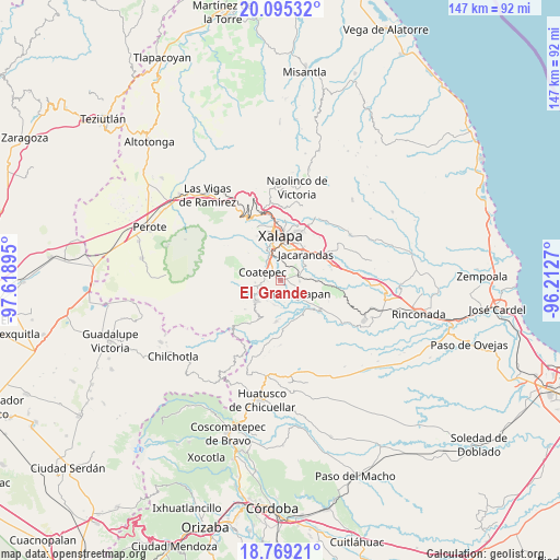
El Grande GPS coordinates[2]
19° 26' 1.032" North, 96° 54' 56.952" West
| Map corner | latitude | longitude |
|---|---|---|
| Upper-left | 20.09532°, | -97.61895° |
| Center: | 19.43362°, | -96.91582° |
| Lower-right: | 18.76921°, | -96.2127° |
| Map W x H: | 147.4×147.5 km | = 91.6×91.7mi |
| max Lat: | 32.7° ⇑55.4% North |
| El Grande: | 19.43362° |
| min Lat: | ⇓44.6% South 14.53588° |
| min Long | El Grande | max Long |
| -117.105° | -96.91582° | -86.73105° |
| W 76%⇐ | ⇒24% E |
Elevation
Elevation of El Grande is 1075 m = 3527 ft, and this is 178.7 m = 586 ft below average elevation for this country.
| Max E: |
3497 m = 11473 ft | 58.6% |
| Avg. | 1253.7 m = 4113 ft | |
| El Grande | 1075 m = 3527 ft | |
Min E: |
-1 m = -3 ft | 41.4% |
See also: Mexico elevation on elevation.city.
Geographical zone
El Grande is located in North Torrid zone (between Equator and Tropic of Cancer). Distance of this Northern Tropic circle is 445.1 km =276.6 mi to North.| Distance of | km | miles | from El Grande |
|---|---|---|---|
| North Pole | 7846.2 | 4875.4 | to North |
| Arctic Circle | 5240.4 | 3256.2 | to North |
| Tropic Cancer | 445.1 | 276.6 | to North |
| Equator | 2160.8 | 1342.7 | to South |


Nearby cities:
15 places around El Grande: (largest is in red/bold)
• Alborada
5 km =3.1 mi,  70°
70°
• Bella Esperanza
5.2 km =3.2 mi,  90°
90°
• Coatepec
5.2 km =3.2 mi,  293°
293°
• Colonia Obrera (Las Puentes)
5.1 km =3.2 mi,  264°
264°
• Independencia
6.2 km =3.9 mi,  211°
211°
• La Laguna
5.7 km =3.5 mi,  340°
340°
• La Orduña
2.9 km =1.8 mi,  313°
313°
• Las Lomas
1.8 km =1.1 mi,  33°
33°
• Mahuixtlan
2.7 km =1.7 mi,  183°
183°
• Monte Blanco
6.4 km =4 mi,  193°
193°
• Pacho Nuevo
6.2 km =3.9 mi,  38°
38°
• Pacho Viejo
5.4 km =3.4 mi,  359°
359°
• San Marcos de León
5.2 km =3.2 mi, 257°
• Tuzamapan
6.5 km =4 mi,  122°
122°
• Zimpizahua
3.4 km =2.1 mi,  269°
269°
Sources, notices
• [Note1] Compared only with cities in Mexico existing in our database
• [Src1] Map data: © OpenStreetMap contributors (CC-BY-SA)
• [Src2] Other city data from geonames.org with taken over terms of usage.
• [Src3] Geographical zone / Annual Mean Temperature by Robert A. Rohde @ Wikipedia
