La Orduña geodata
La Orduña (Veracruz) is a populated place; located in Mexico in America/Mexico_City (GMT-6) time zone. With population of 1,588 people, there are 5434 cities with bigger population in this country. Compared to other cities in Mexico, 55% of cities are located further ↑North; 75.7% of cities are located further ←West and 56.2% of cities have higher elevation than La Orduña. Note1


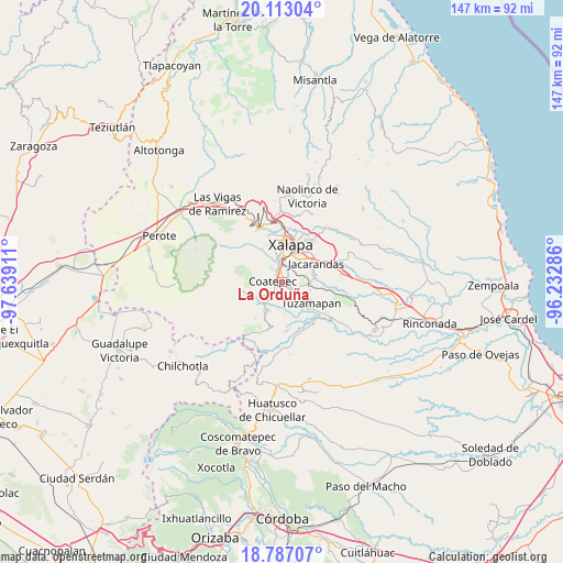
La Orduña GPS coordinates[2]
19° 27' 5.076" North, 96° 56' 9.528" West
| Map corner | latitude | longitude |
|---|---|---|
| Upper-left | 20.11304°, | -97.63911° |
| Center: | 19.45141°, | -96.93598° |
| Lower-right: | 18.78707°, | -96.23286° |
| Map W x H: | 147.4×147.4 km | = 91.6×91.6mi |
| max Lat: | 32.7° ⇑55% North |
| La Orduña: | 19.45141° |
| min Lat: | ⇓45% South 14.53588° |
| min Long | La Orduña | max Long |
| -117.105° | -96.93598° | -86.73105° |
| W 75.7%⇐ | ⇒24.3% E |
Elevation
Elevation of La Orduña is 1149 m = 3770 ft, and this is 104.7 m = 344 ft below average elevation for this country.
| Max E: |
3497 m = 11473 ft | 56.2% |
| Avg. | 1253.7 m = 4113 ft | |
| La Orduña | 1149 m = 3770 ft | |
Min E: |
-1 m = -3 ft | 43.8% |
See also: Mexico elevation on elevation.city.
Geographical zone
La Orduña is located in North Torrid zone (between Equator and Tropic of Cancer). Distance of this Northern Tropic circle is 443.1 km =275.3 mi to North.| Distance of | km | miles | from La Orduña |
|---|---|---|---|
| North Pole | 7844.3 | 4874.2 | to North |
| Arctic Circle | 5238.4 | 3255 | to North |
| Tropic Cancer | 443.1 | 275.3 | to North |
| Equator | 2162.8 | 1343.9 | to South |


Nearby cities:
15 places around La Orduña: (largest is in red/bold)
• Alborada
6.8 km =4.2 mi,  92°
92°
• Coatepec
2.7 km =1.7 mi,  272°
272°
• Colonia Obrera (Las Puentes)
3.9 km =2.4 mi,  229°
229°
• Colonia Úrsulo Galván
5.1 km =3.2 mi,  240°
240°
• Cuauhtémoc
6.3 km =3.9 mi,  315°
315°
• El Grande
2.9 km =1.8 mi,  133°
133°
• Fraccionamiento las Fuentes
7.2 km =4.5 mi,  46°
46°
• La Laguna
3.4 km =2.1 mi,  4°
4°
• Las Lomas
3.2 km =2 mi,  98°
98°
• Mahuixtlan
5 km =3.1 mi,  157°
157°
• Mariano Escobedo
5.2 km =3.2 mi,  350°
350°
• Pacho Nuevo
6.7 km =4.2 mi,  64°
64°
• Pacho Viejo
4 km =2.5 mi,  30°
30°
• San Marcos de León
4.3 km =2.7 mi,  224°
224°
• Zimpizahua
2.3 km =1.4 mi,  212°
212°
Sources, notices
• [Note1] Compared only with cities in Mexico existing in our database
• [Src1] Map data: © OpenStreetMap contributors (CC-BY-SA)
• [Src2] Other city data from geonames.org with taken over terms of usage.
• [Src3] Geographical zone / Annual Mean Temperature by Robert A. Rohde @ Wikipedia
