Bella Esperanza geodata
Bella Esperanza (Veracruz) is a populated place; located in Mexico in America/Mexico_City (GMT-6) time zone. With population of 1,618 people, there are 5348 cities with bigger population in this country. Compared to other cities in Mexico, 55.4% of cities are located further ↑North; 76.5% of cities are located further ←West and 59.9% of cities have higher elevation than Bella Esperanza. Note1


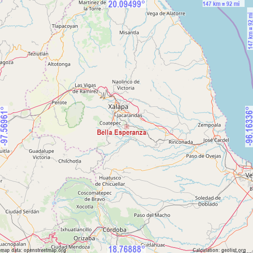
Bella Esperanza GPS coordinates[2]
19° 25' 59.844" North, 96° 51' 59.328" West
| Map corner | latitude | longitude |
|---|---|---|
| Upper-left | 20.09499°, | -97.56961° |
| Center: | 19.43329°, | -96.86648° |
| Lower-right: | 18.76888°, | -96.16336° |
| Map W x H: | 147.4×147.5 km | = 91.6×91.7mi |
| max Lat: | 32.7° ⇑55.4% North |
| Bella Esperanza: | 19.43329° |
| min Lat: | ⇓44.6% South 14.53588° |
| min Long | Bella Esperanza | max Long |
| -117.105° | -96.86648° | -86.73105° |
| W 76.5%⇐ | ⇒23.5% E |
Elevation
Elevation of Bella Esperanza is 1011 m = 3317 ft, and this is 242.7 m = 796 ft below average elevation for this country.
| Max E: |
3497 m = 11473 ft | 59.9% |
| Avg. | 1253.7 m = 4113 ft | |
| Bella Esperanza | 1011 m = 3317 ft | |
Min E: |
-1 m = -3 ft | 40.1% |
See also: Mexico elevation on elevation.city.
Geographical zone
Bella Esperanza is located in North Torrid zone (between Equator and Tropic of Cancer). Distance of this Northern Tropic circle is 445.1 km =276.6 mi to North.| Distance of | km | miles | from Bella Esperanza |
|---|---|---|---|
| North Pole | 7846.3 | 4875.5 | to North |
| Arctic Circle | 5240.4 | 3256.2 | to North |
| Tropic Cancer | 445.1 | 276.6 | to North |
| Equator | 2160.8 | 1342.7 | to South |


Nearby cities:
15 places around Bella Esperanza: (largest is in red/bold)
• Alborada
1.8 km =1.1 mi,  344°
344°
• Chavarrillo
7.6 km =4.7 mi,  96°
96°
• Colonia la Perseverancia
6.9 km =4.3 mi,  358°
358°
• El Chico
4.8 km =3 mi,  41°
41°
• El Grande
5.2 km =3.2 mi,  270°
270°
• Estación Chavarrillo
6 km =3.7 mi, 95°
• Estanzuela
3.2 km =2 mi,  15°
15°
• Fraccionamiento las Fuentes
7.3 km =4.5 mi, 343°
• Jacarandas
7.1 km =4.4 mi,  11°
11°
• La Orduña
7.6 km =4.7 mi,  285°
285°
• Las Lomas
4.4 km =2.7 mi, 290°
• Llano Grande
7.1 km =4.4 mi,  191°
191°
• Mahuixtlan
6 km =3.7 mi,  243°
243°
• Pacho Nuevo
5 km =3.1 mi,  345°
345°
• Tuzamapan
3.4 km =2.1 mi,  174°
174°
Sources, notices
• [Note1] Compared only with cities in Mexico existing in our database
• [Src1] Map data: © OpenStreetMap contributors (CC-BY-SA)
• [Src2] Other city data from geonames.org with taken over terms of usage.
• [Src3] Geographical zone / Annual Mean Temperature by Robert A. Rohde @ Wikipedia
