La Sidra geodata
La Sidra (Veracruz) is a populated place; located in Mexico in America/Mexico_City (GMT-6) time zone. With population of 1,752 people, there are 4957 cities with bigger population in this country. Compared to other cities in Mexico, 66.2% of cities are located further ↑North; 73.8% of cities are located further ←West and 51.9% of cities have higher elevation than La Sidra. Note1


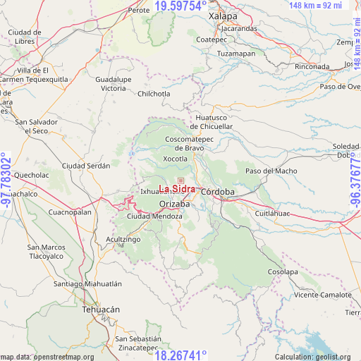
La Sidra GPS coordinates[2]
18° 56' 1.68" North, 97° 4' 47.604" West
| Map corner | latitude | longitude |
|---|---|---|
| Upper-left | 19.59754°, | -97.78302° |
| Center: | 18.9338°, | -97.07989° |
| Lower-right: | 18.26741°, | -96.37677° |
| Map W x H: | 147.9×147.9 km | = 91.9×91.9mi |
| max Lat: | 32.7° ⇑66.2% North |
| La Sidra: | 18.9338° |
| min Lat: | ⇓33.8% South 14.53588° |
| min Long | La Sidra | max Long |
| -117.105° | -97.07989° | -86.73105° |
| W 73.8%⇐ | ⇒26.2% E |
Elevation
Elevation of La Sidra is 1342 m = 4403 ft, and this is 88.3 m = 290 ft above average elevation for this country.
| Max E: |
3497 m = 11473 ft | 51.9% |
| La Sidra | 1342 m 4403 ft | |
| Avg. | 1253.7 m = 4113 ft | |
Min E: |
-1 m = -3 ft | 48.1% |
See also: Mexico elevation on elevation.city.
Geographical zone
La Sidra is located in North Torrid zone (between Equator and Tropic of Cancer). Distance of this Northern Tropic circle is 500.7 km =311.1 mi to North.| Distance of | km | miles | from La Sidra |
|---|---|---|---|
| North Pole | 7901.8 | 4909.9 | to North |
| Arctic Circle | 5295.9 | 3290.7 | to North |
| Tropic Cancer | 500.7 | 311.1 | to North |
| Equator | 2105.2 | 1308.1 | to South |


Nearby cities:
15 places around La Sidra: (largest is in red/bold)
• Atzacan
3 km =1.9 mi,  186°
186°
• Barrio de San Miguel
4.8 km =3 mi,  266°
266°
• Chicola
4.7 km =2.9 mi,  219°
219°
• Colonia Ejidal
5.5 km =3.4 mi,  242°
242°
• Contla
5.2 km =3.2 mi,  342°
342°
• Cumbre de Metlac
5.7 km =3.5 mi,  98°
98°
• Dos Ríos
5.6 km =3.5 mi,  76°
76°
• El Mirador
5.6 km =3.5 mi,  228°
228°
• La Perla
5.7 km =3.5 mi,  263°
263°
• Lagunilla
3.6 km =2.2 mi,  134°
134°
• Macuilácatl Grande
5.6 km =3.5 mi,  297°
297°
• Mariano Escobedo
5.7 km =3.5 mi,  246°
246°
• Moyoapan
4.1 km =2.5 mi,  117°
117°
• Revolución
5.3 km =3.3 mi, 193°
• Rincón Grande
2.3 km =1.4 mi, 303°
Sources, notices
• [Note1] Compared only with cities in Mexico existing in our database
• [Src1] Map data: © OpenStreetMap contributors (CC-BY-SA)
• [Src2] Other city data from geonames.org with taken over terms of usage.
• [Src3] Geographical zone / Annual Mean Temperature by Robert A. Rohde @ Wikipedia
