Iturbide geodata
Iturbide (Nuevo León) is a seat of a second-order administrative division; located in Mexico in America/Monterrey (GMT-6) time zone. With population of 1,896 people, there are 4591 cities with bigger population in this country. Compared to other cities in Mexico, 91.3% of cities are located further ↓South; 62.7% of cities are located further →East and 50.5% of cities have lower elevation than Iturbide. Note1


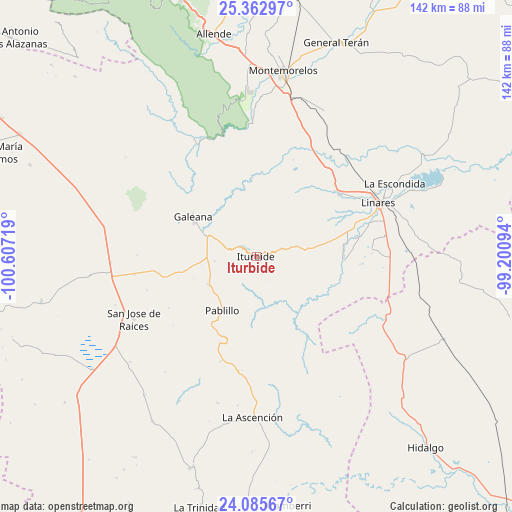
Iturbide GPS coordinates[2]
24° 43' 33.456" North, 99° 54' 14.616" West
| Map corner | latitude | longitude |
|---|---|---|
| Upper-left | 25.36297°, | -100.60719° |
| Center: | 24.72596°, | -99.90406° |
| Lower-right: | 24.08567°, | -99.20094° |
| Map W x H: | 142×142 km | = 88.2×88.2mi |
| max Lat: | 32.7° ⇑8.7% North |
| Iturbide: | 24.72596° |
| min Lat: | ⇓91.3% South 14.53588° |
| min Long | Iturbide | max Long |
| -117.105° | -99.90406° | -86.73105° |
| W 37.3%⇐ | ⇒62.7% E |
Elevation
Elevation of Iturbide is 1457 m = 4780 ft, and this is 203.3 m = 667 ft above average elevation for this country.
| Max E: |
3497 m = 11473 ft | 49.5% |
| Iturbide | 1457 m 4780 ft | |
| Avg. | 1253.7 m = 4113 ft | |
Min E: |
-1 m = -3 ft | 50.5% |
See also: Mexico elevation on elevation.city.
Geographical zone
Iturbide is located in North temperate zone (between Tropic of Cancer and the Arctic Circle). Distance of this Northern Tropic circle is 143.4 km =89.1 mi to South.| Distance of | km | miles | from Iturbide |
|---|---|---|---|
| North Pole | 7257.8 | 4509.8 | to North |
| Arctic Circle | 4651.9 | 2890.6 | to North |
| Tropic Cancer | 143.4 | 89.1 | to South |
| Equator | 2749.3 | 1708.3 | to South |


Nearby cities:
15 places around Iturbide: (largest is in red/bold)
• Catarino Rodríguez
44.1 km =27.4 mi,  287°
287°
• Galeana
20.5 km =12.7 mi,  302°
302°
• General Lucio Blanco
50.7 km =31.5 mi,  89°
89°
• Guadalupe
47.5 km =29.5 mi,  66°
66°
• Hualahuises
29 km =18 mi,  52°
52°
• La Ascensión
44.7 km =27.8 mi,  181°
181°
• La Escondida
43.9 km =27.3 mi,  62°
62°
• Laguna de Labradores
23.7 km =14.7 mi, 295°
• Linares
37 km =23 mi, 66°
• Pablillo
17.5 km =10.9 mi,  211°
211°
• Rayones
36.7 km =22.8 mi,  332°
332°
• Río Verde
41.3 km =25.7 mi, 61°
• San José de Raíces
38.1 km =23.7 mi,  243°
243°
• Villa Mainero
34.5 km =21.4 mi,  122°
122°
• Villagrán
50.4 km =31.3 mi, 124°
Sources, notices
• [Note1] Compared only with cities in Mexico existing in our database
• [Src1] Map data: © OpenStreetMap contributors (CC-BY-SA)
• [Src2] Other city data from geonames.org with taken over terms of usage.
• [Src3] Geographical zone / Annual Mean Temperature by Robert A. Rohde @ Wikipedia
