Pablillo geodata
Pablillo (Nuevo León) is a populated place; located in Mexico in America/Monterrey (GMT-6) time zone. With population of 923 people, there are 9459 cities with bigger population in this country. Compared to other cities in Mexico, 91% of cities are located further ↓South; 63.9% of cities are located further →East and 77.8% of cities have lower elevation than Pablillo. Note1


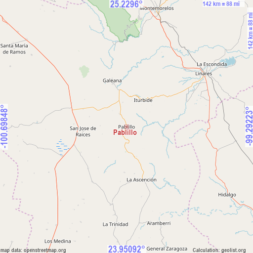
Pablillo GPS coordinates[2]
24° 35' 30.804" North, 99° 59' 43.26" West
| Map corner | latitude | longitude |
|---|---|---|
| Upper-left | 25.2296°, | -100.69848° |
| Center: | 24.59189°, | -99.99535° |
| Lower-right: | 23.95092°, | -99.29223° |
| Map W x H: | 142.2×142.2 km | = 88.4×88.4mi |
| max Lat: | 32.7° ⇑9% North |
| Pablillo: | 24.59189° |
| min Lat: | ⇓91% South 14.53588° |
| min Long | Pablillo | max Long |
| -117.105° | -99.99535° | -86.73105° |
| W 36.1%⇐ | ⇒63.9% E |
Elevation
Elevation of Pablillo is 2085 m = 6841 ft, and this is 831.3 m = 2727 ft above average elevation for this country.
| Max E: |
3497 m = 11473 ft | 22.2% |
| Pablillo | 2085 m 6841 ft | |
| Avg. | 1253.7 m = 4113 ft | |
Min E: |
-1 m = -3 ft | 77.8% |
See also: Mexico elevation on elevation.city.
Geographical zone
Pablillo is located in North temperate zone (between Tropic of Cancer and the Arctic Circle). Distance of this Northern Tropic circle is 128.4 km =79.8 mi to South.| Distance of | km | miles | from Pablillo |
|---|---|---|---|
| North Pole | 7272.7 | 4519 | to North |
| Arctic Circle | 4666.8 | 2899.8 | to North |
| Tropic Cancer | 128.4 | 79.8 | to South |
| Equator | 2734.4 | 1699.1 | to South |


Nearby cities:
15 places around Pablillo: (largest is in red/bold)
• Aramberri
57.6 km =35.8 mi,  161°
161°
• Catarino Rodríguez
43.3 km =26.9 mi,  310°
310°
• Galeana
27.1 km =16.8 mi,  342°
342°
• Hualahuises
45.8 km =28.5 mi,  44°
44°
• Iturbide
17.5 km =10.9 mi,  31°
31°
• La Ascensión
30.9 km =19.2 mi, 164°
• La Escondida
59.6 km =37 mi,  53°
53°
• La Trinidad
55.2 km =34.3 mi,  186°
186°
• Laguna de Labradores
27.9 km =17.3 mi,  333°
333°
• Linares
52.4 km =32.6 mi,  55°
55°
• Rayones
48 km =29.8 mi,  350°
350°
• Río Verde
57.1 km =35.5 mi, 53°
• San José de Raíces
24.8 km =15.4 mi,  264°
264°
• Villa Mainero
38.6 km =24 mi,  95°
95°
• Villagrán
52.7 km =32.7 mi, 104°
Sources, notices
• [Note1] Compared only with cities in Mexico existing in our database
• [Src1] Map data: © OpenStreetMap contributors (CC-BY-SA)
• [Src2] Other city data from geonames.org with taken over terms of usage.
• [Src3] Geographical zone / Annual Mean Temperature by Robert A. Rohde @ Wikipedia
